
Casalfiumanese
About twenty kilometres from Imola, along the valley of the Sillaro stream, the municipal territory of Casalfiumanese stretches between the lower plain and the first hills of the Bolognese Apennines, covering an elevation range from 50 to nearly 500 metres above sea level. The main town, sitting at 125 metres above sea level, has approximately […]
Discover Casalfiumanese
About twenty kilometres from Imola, along the valley of the Sillaro stream, the municipal territory of Casalfiumanese stretches between the lower plain and the first hills of the Bolognese Apennines, covering an elevation range from 50 to nearly 500 metres above sea level. The main town, sitting at 125 metres above sea level, has approximately 3,476 inhabitants spread across the centre and the many hamlets scattered over the surrounding hills.
Understanding what to see in Casalfiumanese means crossing a landscape where clay badlands alternate with orchards and vineyards, and where Romanesque churches and medieval towers mark the ridgelines as reference points for those travelling these roads along the border between Romagna and the Bolognese area.
History and origins of Casalfiumanese
The name Casalfiumanese most likely derives from the combination of the Latin term casale — a rural settlement, a cluster of houses linked to farming — and the adjective fiumanese, which refers to the proximity of a watercourse. The most direct reference is to the Sillaro stream, which runs through the entire length of the municipal territory and has shaped the economic and social life of the area since antiquity.
Some scholars have suggested a connection with the generic term flumen, but the most solid identification remains the one linked to the Sillaro, a watercourse that historically marked the boundary between the Bolognese and Romagnol areas. The earliest documented mention of the place name dates to the medieval period, when the territory was already organised into small settlements tied to the agricultural and pastoral activities of the valley.
During the Middle Ages, the territory of Casalfiumanese was contested between various lordships and ecclesiastical powers. Its position along the Sillaro valley, a transit route between the Po plain and the Apennine passes, gave the area a strategic importance that went beyond its demographic size. In the 13th and 14th centuries, the zone came under the influence of noble families linked to the Commune of Imola and the Church of Bologna, passing through alternating phases of autonomy and subjugation.
The fortifications scattered across the territory — watchtowers, tower-houses and small castles — largely date from this period and reflect the need to control communication routes and defend rural communities from incursions. With the consolidation of the Papal States, the territory was incorporated into the administrative structures of the Legation of Bologna, while still retaining a strong rural identity.
The modern evolution of Casalfiumanese mirrors the transformations of the entire Bolognese hill area. After the Unification of Italy in 1861, the municipality was confirmed in its territorial configuration, which includes numerous hamlets such as Sassoleone, Carseggio, Sassatello and other scattered localities on the ridges. Over the course of the 20th century, the population experienced the rural exodus that affected many Apennine areas: from the demographic peaks of the first half of the century, numbers gradually declined and stabilised at around the current 3,476 residents.
The patron saint of the municipality is Pope Gregory I, known as Gregory the Great, whose feast day is celebrated on 12 March. During the Second World War, the territory was affected by fighting along the Gothic Line, and several episodes linked to the partisan Resistance are recorded in local memory and in the commemorative markers scattered across the hill hamlets.
What to see in Casalfiumanese: 5 top attractions
1. Parish church of San Martino in Pedriolo
The church of San Martino in Pedriolo stands in the hamlet of the same name, a few kilometres north of the main town. The building, of ancient origin and remodelled several times over the centuries, retains a single-nave structure with architectural elements reflecting its various phases of intervention. The dedication to Saint Martin of Tours is common to many rural churches in the Emilia-Romagna area founded during the early Middle Ages along transit routes. The interior houses sacred furnishings and artworks that document the devotion of the rural communities of the Sillaro valley. The church’s position, on a gentle rise overlooking the surrounding fields, offers a meaningful vantage point for understanding the historical territorial organisation of the area.
2. The hamlet of Sassoleone
Sassoleone is one of the most significant hamlets in the municipality, located in the hilly part of the territory at a higher altitude than the main town. The settlement preserves a layout typical of Apennine hill villages, with sandstone buildings arranged along the ridge and closely packed together for defensive and climatic reasons. The parish church of the hamlet has been the focal point of community life for centuries. The surrounding area features oak and chestnut woods and geological outcrops of considerable interest. Sassoleone serves as a starting point for hikes along the trails connecting the hill hamlets of the municipality and represents a significant example of rural Apennine architecture in Emilia.
3. The badlands of the Sillaro valley
The territory of Casalfiumanese is home to badland formations of great geological and landscape interest. The calanchi (badlands), formed by the erosion of Pliocene clays through rainwater, create a landscape of sharp crests, deep furrows and grey walls that contrast with the green of the surrounding vegetation. These formations are particularly visible in the southern part of the municipal territory, where the terrain rises towards the Apennines. From a naturalistic perspective, the badlands support a specific flora adapted to extreme conditions of aridity and soil instability. For visitors interested in geology and photography, these formations offer unique scenery, especially during the hours of raking light when shadows accentuate the terrain’s morphology.
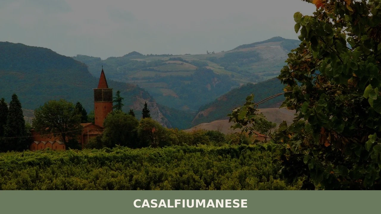
4. The tower and the historic centre of the main town
The centre of Casalfiumanese retains traces of its medieval layout, with a compact nucleus where wall structures and doorways from periods predating modern renovations can still be identified. The presence of a tower, a recurring element in the architecture of villages in the Sillaro valley, signals the site’s former defensive and territorial control function. The urban layout follows the logic of road-villages, developed along a main road axis running through the settlement. Walking through the centre allows visitors to observe the layers of construction that document the village’s evolution from the Middle Ages to the 20th century. The main square, with its institutional buildings and church, represents the social and civic hub of the community.
5. Hiking trails between the hill hamlets
The network of trails connecting the hamlets of the municipality of Casalfiumanese is a resource of considerable value for those who practise trekking and hiking. The routes develop between 100 and 500 metres in altitude, crossing diverse environments: cultivated valley floors, clay slopes with badlands, mixed broadleaf woods and panoramic ridges.
Some of these paths follow historical routes — mule tracks and cart roads — used for centuries by rural communities to link villages to one another and to the valley-floor markets. The hamlets of Carseggio, Sassatello and Sassoleone are natural stops along circular itineraries that can be completed in a day. Signposting, maintained in collaboration with local authorities, helps with orientation even for those unfamiliar with the territory.
What to eat in Casalfiumanese: local cuisine and regional products
The gastronomic tradition of Casalfiumanese reflects the municipality’s position on the border between Bolognese and Romagnol food cultures, in a territory where the plain meets the hills. The local cuisine is the result of centuries of peasant economy based on wheat cultivation, pig farming, foraging for wild fruits and wine production. The climate, with hot summers and moderately cold winters, has favoured the cultivation of orchards — cherry, peach and apricot trees — that define the hillside agricultural landscape.
Traditional dishes follow a logic of making full use of available resources, with robust preparations designed to sustain work in the fields.
Among the dishes that define the local table, tagliatelle al ragù holds a central place: the pasta sheet, rolled by hand with a rolling pin on a wooden board and cut into ribbons roughly seven millimetres wide, is dressed with a beef and pork ragù slow-cooked for hours with a soffritto of celery, carrot and onion, tomato and a splash of broth. Tortellini in brodo, a direct inheritance from the Bolognese tradition, appear on feast days and during winter celebrations, with a filling that combines pork loin, cured ham, mortadella, Parmigiano and nutmeg. Passatelli, typical of the Romagnol area, are made from a dough of breadcrumbs, eggs and grated Parmigiano Reggiano, extruded through a special press directly into boiling meat broth.
The territory falls within the production area of several recognised products of the Emilia-Romagna tradition. Parmigiano Reggiano, a PDO cheese whose production zone covers the entire province of Bologna, is found in local pantries and recipes as a fundamental ingredient. The proximity to the Imola and Faenza area places Casalfiumanese within the fresh fruit production belt, particularly peaches, apricots, cherries and plums, which supply both direct consumption and processing into jams and preserves. Pork-based cured meats — prepared according to traditional Emilian butchering techniques — include cotechino, salami and ciccioli, processed during the cold months following a production calendar that has remained essentially unchanged.
The calendar of local food festivals follows the rhythm of the agricultural seasons.
Summer and autumn sagre in the hill hamlets offer opportunities to taste home-made preparations rarely found in commercial restaurants: crescentine fritte (also known locally as gnocco fritto), tigelle, borlenghi and other baked specialities. The weekly markets of the Imola district allow direct purchase of fruit, vegetable and dairy products from local producers. Nearby Imola, with its markets and food shops, is the main commercial reference point for products from the territory.
Wine production in the territory is part of the broader context of the Bolognese and Romagnol hills, where vine cultivation has ancient roots. The vineyards of the area, on hillside slopes between 100 and 300 metres in altitude, produce grapes from which wines falling under local designations are made. Albana, a white grape variety widespread in the Romagnol area, and Sangiovese, the base of local reds, are the most representative varieties. The local tradition also includes the production of wines from minor indigenous grape varieties, vinified in small quantities by family-run farms operating in the hilly part of the municipality.
When to visit Casalfiumanese: the best time of year
Spring, from April to June, is the most favourable period to visit Casalfiumanese, particularly for those planning to walk the hill trails and observe the agricultural landscape at the height of the orchard blossom.
Mild temperatures and long days allow comfortable excursions, and the badlands, still damp from spring rains, display particularly vivid chromatic contrasts. The patron saint’s feast on 12 March, dedicated to Pope Gregory I, symbolically marks the start of the season and serves as a moment of gathering for the local community. Autumn, from September to November, offers equally favourable conditions: the grape harvest, the picking of late fruits and the colours of the foliage make the hill landscape especially photogenic.
Summer can be hot in the lowland areas, with temperatures frequently exceeding 30 degrees between July and August, but the hill hamlets benefit from a more ventilated climate. Summer sagre, concentrated between June and September, enliven the hamlets with evenings dedicated to food and folk music. Winter is the quietest period: fog on the plain and cold temperatures in the higher areas reduce visitor numbers, but those seeking silence and a genuine feel find ideal conditions during this season.
For those travelling with specific goals — landscape photography, birdwatching, geological study of the badlands — each season has its own characteristics that justify a visit.
How to reach Casalfiumanese
Casalfiumanese can be reached by car from the A14 Bologna–Ancona motorway, exiting at the Imola toll station, from which the village is about 12 kilometres away and reachable in 15–20 minutes along the provincial road that follows the Sillaro valley. From Bologna, the total journey is approximately 45 kilometres, just under an hour’s drive. From Florence, via the A1 to Bologna and then the A14, the distance is around 130 kilometres. The nearest airport is Bologna’s Guglielmo Marconi, located about 50 kilometres away and reachable in 40–50 minutes by car.
The nearest railway station is Imola, served by the Bologna–Ancona line with frequent regional and long-distance connections. From Imola, a bus service operated by TPER connects the main town and some hamlets, with more frequent timetables on weekdays and reduced services on holidays. For those arriving by train, it is advisable to check bus-train connection times or consider hiring a car to move easily between the municipality’s scattered hamlets. The internal road network within the municipality is in good condition, but some roads leading to the higher hamlets are narrow and winding, requiring careful driving.
Other villages to discover in Emilia-Romagna
Visitors to Casalfiumanese can extend their exploration of the Emilia-Romagna territory towards other centres that share similar historical and landscape features.
Imola, about fifteen minutes away by car, is the natural urban complement to a visit to the Sillaro valley: the Sforza fortress, the historic centre with its Cathedral and porticoes, the international racetrack and the lively commercial fabric offer a full day of things to do. The historical link between Casalfiumanese and Imola is deep and well documented: for centuries the Imola market was the trading point for agricultural products from the surrounding hills, and even today the economic and social relationship between the two centres remains close.
For a broader itinerary through the villages of Emilia, it is worth considering a stop at San Pietro in Cerro, in the province of Piacenza, reachable in about an hour and a half by car along the Via Emilia. This small centre on the Piacenza plain offers an interesting comparison with Casalfiumanese: while the latter extends between plain and hills with a varied and geologically complex landscape, San Pietro in Cerro spreads across the Po plain with a different territorial organisation, linked to large-scale land ownership and lowland reclamation.
Together, the two villages provide a complete reading of the different identities within Emilia-Romagna, from the clay hills to the alluvial plain, from small peasant holdings to the great estates of the Po valley. An itinerary of three or four days that includes both — with Imola as a logistical base — allows visitors to grasp these differences with the time needed to observe them without rushing.
In Emilia-Romagna More villages to discover
Bobbio
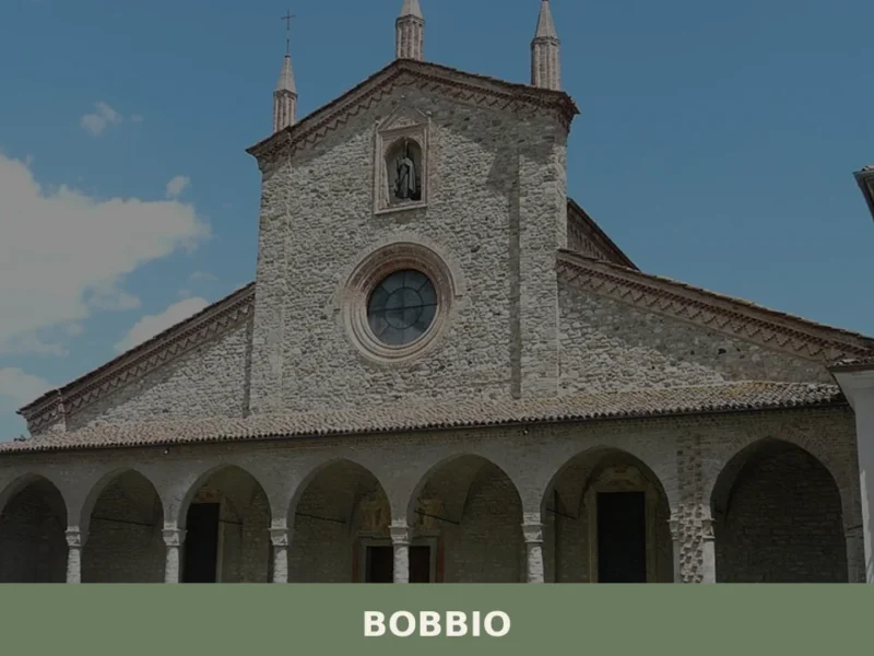
What to see in Bobbio: a town of 3,710 at 272 m in the Trebbia valley, with a 614 AD abbey, the medieval Ponte Gobbo and a hilltop castle. Plan your visit now.
Bettola
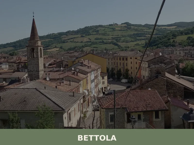
What to see in Bettola: a Val Nure village at 329 m with 2,983 residents. Discover the Sanctuary of the Madonna della Quercia, Piacenza DOP cured meats and how to get there.
Borgonovo Val Tidone
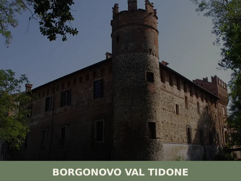
What to see in Borgonovo Val Tidone: 7,774 residents, a medieval castle, the Santa Maria Assunta church and Piacenza cuisine. Plan your visit with this complete guide.


📝 Incorrect information or updates?
Help us keep the Casalfiumanese page accurate and up to date.