
Carpineto Sinello
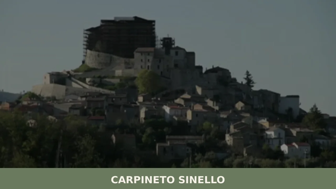
At 381 metres above sea level, on the ridge line separating the Sinello valley from the Appello stream valley, Carpineto Sinello has just 480 inhabitants today — less than a fifth of the nearly two thousand recorded in early twentieth-century censuses. The demographic data tells the story of a hilltop centre in the Chieti area […]
Discover Carpineto Sinello
At 381 metres above sea level, on the ridge line separating the Sinello valley from the Appello stream valley, Carpineto Sinello has just 480 inhabitants today — less than a fifth of the nearly two thousand recorded in early twentieth-century censuses. The demographic data tells the story of a hilltop centre in the Chieti area that has watched entire generations leave for coastal cities and abroad. Asking what to see in Carpineto Sinello means exploring what remains and what endures: a compact urban core, a parish church dedicated to Saint Michael the Archangel, and an agricultural landscape still actively worked.
History and origins of Carpineto Sinello
The place name is composed of two transparent elements: “Carpineto” derives from carpinus, the European hornbeam common in the area’s hill woodlands, while “Sinello” identifies the river flowing northeast of the settlement, distinguishing this municipality from the other Carpinetos on the Italian peninsula — Carpineto Romano in Lazio and Carpineto della Nora in the province of Pescara. The specification “Sinello” was officially added in 1863, after national unification, to avoid duplications in the postal system of the Kingdom of Italy.
The earliest documentary records of the village date to the Norman period. The territory fell within the feudal holdings that gravitated around the defensive system of the middle Sinello valley, an area contested between the Counts of Manoppello and various baronial families of the Kingdom of Naples. Like many centres in the Chieti hinterland, Carpineto passed through several feudal lordships — including the D’Avalos family — before the abolition of feudalism in 1806. The local economy was based on cereal farming and sheep rearing, activities that connected these hills to the transhumance routes towards the Tavoliere delle Puglie plain.
Over the course of the nineteenth and twentieth centuries, the village underwent a progressive depopulation accelerated by the two world wars and emigration towards Argentina, Venezuela, and the industrial areas of Northern Italy. The traces of this exodus can still be read in the shuttered houses of the old town and in Carpineto family names found in Italian communities overseas.
What to see in Carpineto Sinello: 5 main attractions
1. Church of San Michele Arcangelo
The main place of worship in the village, dedicated to the patron saint celebrated on 29 September. The current structure features elements attributable to eighteenth-century interventions, with a simple masonry façade and a single-nave interior. Inside, liturgical furnishings and processional statues linked to popular devotion to the Archangel are preserved — a recurring figure in the hill and mountain settlements of Abruzzo.
2. Old town and medieval urban fabric
The historic core of Carpineto Sinello retains a narrow, vertical urban layout, with dwellings in local stone pressed against one another following the defensive logic of ridge-top villages. External masonry staircases, doorways with carved stone lintels, and semi-basement cellars at street level document a housing model widespread across the entire hilly belt between the Sinello and the Sangro rivers.
3. Ruins and traces of the feudal structure
In the upper part of the settlement, wall remnants attributable to the village’s ancient defensive apparatus can be identified. This is not a preserved castle, but rather fragments — stretches of walls, foundations, unusually thick walls in certain houses — indicating the presence of an original fortified structure around which the centre developed over the centuries.
4. Agricultural landscape of the Sinello valley
The municipal territory extends across hills cultivated with wheat, vines, and olive trees, with a significant portion of uncultivated land and coppice woodland. From the highest points of the village, on clear days, the view reaches the Adriatic coastline to the east and the buttresses of the Maiella massif to the west. The Sinello, a modest watercourse but one that is decisive for the geographical identity of the area, marks the natural boundary of the district.
5. Fountains and rural water points
Along the roads connecting the centre to the surrounding farmland, stone fountains and drinking troughs can be found — essential infrastructure for fieldwork and pastoral life. These hydraulic structures, often datable to between the nineteenth and early twentieth centuries, constitute a minor but significant catalogue of Abruzzo’s functional rural architecture.
Food and local produce
The table in Carpineto Sinello reflects the peasant cooking of the Chieti hills: handmade pasta — sagne, chitarrina, ricotta ravioli — dressed with lamb ragù or slow-cooked tomato sauce. Ventricina, a cured meat made from pork cut by hand with a knife tip and seasoned with sweet and hot pepper, is the most representative product of this part of the Vasto area. Extra virgin olive oil is also produced from indigenous cultivars, particularly the Gentile di Chieti variety, and Montepulciano d’Abruzzo DOC wine from vineyards on south and southeast-facing slopes.
Dining options in the village are limited to a handful of establishments — a wider selection can be found in the municipalities of the Sinello valley and the Vasto area — but during patron saint festivities and summer food festivals, communal kitchens are set up where visitors can taste dishes prepared according to orally transmitted recipes. Local pecorino cheese, aged in natural cellars, accompanies bread baked in wood-fired ovens still operational in some houses in the centre.
When to visit Carpineto Sinello: the best time
The feast of San Michele Arcangelo, on 29 September, is the most significant occasion in the village’s civic and religious calendar: a procession, solemn Mass, and a gathering of the community, including emigrants who return for the event. Summer — from June to September — offers the most favourable weather, with temperatures on the hill remaining more moderate than on the coast, rarely exceeding 32°C. It is also the period when most initiatives organised by the pro loco association and the Municipality are concentrated.
Spring, between April and May, is ideal for walking the paths through wheat fields and flowering olive groves. Autumn coincides with the grape harvest and olive picking, activities that on family-run farms are still largely carried out by hand. Winter is the quietest period: the village is reduced to its permanent residents alone, the cold is moderate but damp, and fog can close off the view over the valley for days at a time.
How to reach Carpineto Sinello
By car from the north or south, the most convenient motorway exit is Vasto Sud–Montenero di Bisaccia on the A14 Adriatica, from which you continue along the Sinello valley road for approximately 25 kilometres. From Chieti the route is around 80 km, almost entirely on provincial roads through the hills. From Pescara, the distance is approximately 100 km, about one hour and forty minutes of driving.
The nearest railway station is Vasto–San Salvo, on the Adriatic line, about 30 km away: from there it is necessary to continue by private vehicle or local bus, with limited frequencies. The reference airport is Pescara’s d’Annunzio, approximately 110 km away. Those arriving from Rome (about 260 km) can choose between the A25 to Pescara and then the A14, or the state road crossing inland Abruzzo via Castel di Sangro.
What to see in Carpineto Sinello and in nearby villages in Abruzzo
The hilly territory between the Sinello and the Sangro is dotted with small municipalities whose histories run parallel to that of Carpineto: rural villages that grew around a church and a defensive nucleus, expanded through agriculture, and were emptied by emigration. A few kilometres away, in the same province of Chieti, Archi is worth a stop — a centre in the middle Sangro valley with a layered urban layout and a commanding position over the confluence of the Sangro and Aventino rivers. Comparing the two villages reveals two variants of the same Abruzzo hilltop settlement model.
For those wishing to extend their exploration towards inland and mountainous Abruzzo, the leap is to the province of L’Aquila: Cagnano Amiterno, in the upper Aterno valley, offers a radically different landscape — higher altitude, harsher winters, an economy historically tied to pastoralism and highland grazing. The geographical distance between these villages corresponds to a cultural and environmental distance that conveys the internal variety of Abruzzo better than any summary could.
In Abruzzo More villages to discover
Castel di Ieri
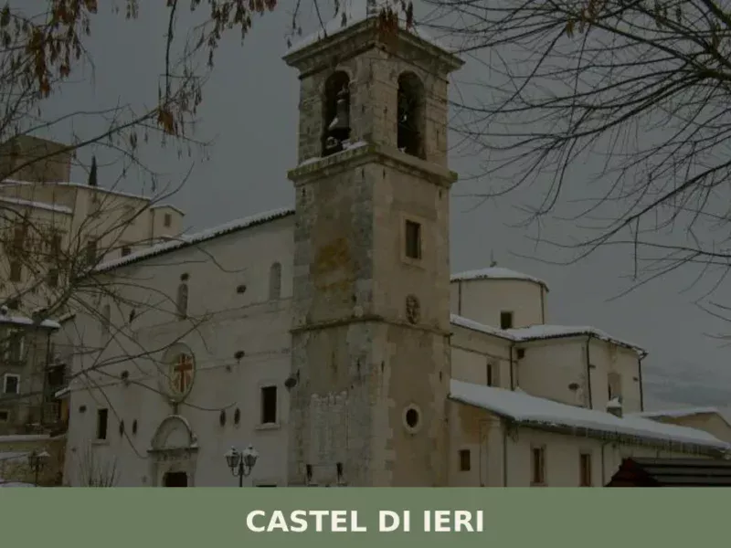
In Castel di Ieri, a village of 289 registered inhabitants at 519 metres above sea level in the Valle Subequana, the most significant feature lies underground: an Italic temple from the 1st century BC, unearthed during the 1980s, which redrew the archaeological map of inland Abruzzo. Anyone looking into what to see in Castel di […]
Frisa
At 237 metres above sea level, on the plain that connects the Chieti hills to the Adriatic coast, Frisa has a current population of 1,620 and a territory dominated by olive groves and arable land. The municipality, in the province of Chieti, retains in its urban layout the marks of an almost total reconstruction following […]
Carpineto della Nora
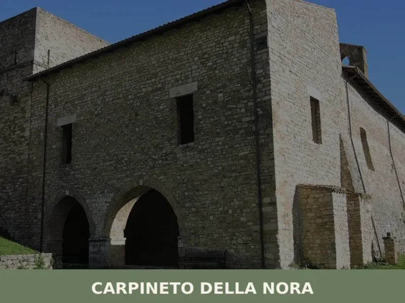
At 535 metres above sea level, on the ridge separating the Nora valley from the Pescara plain, Carpineto della Nora has a current population of 536 — a number that has halved since post-war censuses. Anyone looking into what to see in Carpineto della Nora will find a settlement built entirely from local stone, spread […]


📝 Incorrect information or updates?
Help us keep the Carpineto Sinello page accurate and up to date.