
Castel di Casio
In February 1944, during the German retreat along the Gothic Line, the bridges over the Limentra di Treppio torrent were blown up one by one, cutting the territory of Castel di Casio in two. That act of destruction left a lasting mark on the collective memory of a mountain municipality that, as far back as […]
Discover Castel di Casio
In February 1944, during the German retreat along the Gothic Line, the bridges over the Limentra di Treppio torrent were blown up one by one, cutting the territory of Castel di Casio in two. That act of destruction left a lasting mark on the collective memory of a mountain municipality that, as far back as the Middle Ages, had built its existence on controlling the passes between Bologna and Tuscany.
Today, at 533 metres above sea level, with its 3,436 inhabitants spread between the main settlement and the Apennine hamlets, the village preserves its original defensive layout and a network of trails running through chestnut and beech forests. Asking what to see in Castel di Casio means tracing centuries of layered history among towers, parish churches and watermills.
History and origins of Castel di Casio
The place name “Castel di Casio” appears for the first time in documents from the Abbey of Nonantola dating to the 9th century, when the term Castrum Cassii referred to a fortification built to protect a pre-existing settlement. The most widely accepted etymology traces “Casio” to the Latin caseus — cheese — or to the Roman personal name Cassius, linked to a possible villa rustica from the imperial period. In either case, the reference points to an agro-pastoral economy that characterised the area for centuries.
The prefix “Castel” documents the presence of a fortified structure, probably a Lombard watchtower, later expanded during the Carolingian era to control traffic along the Limentra valley.
In the 12th century the castle came under the rule of the Alberti counts of Prato, one of the most powerful feudal families of the Tuscan-Emilian Apennines, who turned it into a strategic outpost in the struggle between Guelphs and Ghibellines. In 1219 the territory was ceded to the Commune of Bologna, which reinforced the defensive walls and established a weekly market to encourage settlement. Its position along the road connecting Bologna to Pistoia ensured Castel di Casio a lasting commercial role. In 1337 the village suffered a siege by Visconti troops, and the subsequent reconstruction redefined the urban layout that partly survives to this day, with the compact core arranged around the central square and the remains of the perimeter walls.
The modern era brought deep transformations. During the Napoleonic period, in 1805, Castel di Casio became an autonomous municipality within the Department of the Reno. The population, which by the mid-19th century exceeded six thousand inhabitants thanks to the charcoal industry and chestnut cultivation, began to decline sharply in the 20th century due to emigration towards Bologna and the industrial cities of the north.
The construction of the Porrettana railway, inaugurated in 1864 as Italy’s first trans-Apennine rail link, skirted the municipal territory without crossing it directly, contributing to the gradual isolation of the higher hamlets. The Second World War left visible scars: the passage of the Gothic Line between 1944 and 1945 caused widespread destruction and the near-total evacuation of the civilian population.
What to see in Castel di Casio: 5 key attractions
1. Church of San Biagio
The parish church dedicated to San Biagio (Saint Blaise), patron saint of the village celebrated on 3 February, stands in the upper part of the historic centre, in a commanding position overlooking the Limentra valley. The current building dates from an 18th-century reconstruction on medieval foundations, with a façade in local sandstone and a square-plan bell tower visible from several kilometres away. Inside, it houses a polychrome marble high altar and several canvases attributed to Bolognese workshops of the 17th century. The single nave, with a coffered ceiling restored after the war following the damage of 1944, hosts each year the patron saint’s procession, accompanied by the blessing of the throat according to the traditional rite of San Biagio.
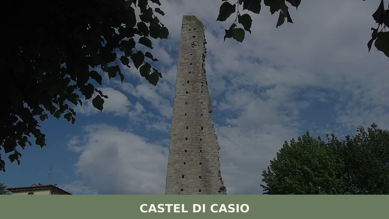
2. Medieval tower and castle remains
Of the original fortification, documented as early as the 9th century, a stretch of squared-stone masonry and the base of a watchtower approximately eight metres tall remain, now incorporated into a residential building in the northern part of the village. The structure, with walls over a metre thick, features splayed arrow slits typical of 12th–13th century defensive architecture. The perimeter of the ancient castle is still readable in the curving layout of the streets in the historic centre, which follow the line of the walls demolished in the modern period. The highest point offers a direct view of the confluence of the Limentra di Treppio and the eastern Limentra — the same strategic position that justified the construction of the fortress.
3. Ponte della Venturina
In the hamlet of the same name, on the border with Tuscany, the Ponte della Venturina crosses the Limentra torrent with a sandstone arch dating to the late medieval period. The structure, rebuilt several times after seasonal floods, retains its humpback design that allowed the passage of carts and pack animals along the road to Pistoia. La Venturina served for centuries as a customs point between the Papal States and the Grand Duchy of Tuscany, and the foundations of a customs building are still visible on the left bank of the torrent. The hamlet itself, with its stone buildings aligned along the main road, forms one of the most architecturally coherent clusters in the entire municipality.
4. Trail of the Mills along the Limentra
A hiking route of approximately six kilometres, classified as a CAI trail, follows the course of the Limentra connecting Castel di Casio to the hamlet of Badi. Along the way, walkers encounter the remains of four watermills that were active until the 1950s, when agricultural mechanisation and depopulation led to their abandonment. The structures, built from local stone with diversion channels still partially visible, document a production system that for centuries ground the valley’s grain and chestnuts into flour destined for the markets of Bologna. The modest elevation gain — approximately 120 metres — and the natural surface make the route suitable for families with children as well, particularly between April and October.
5. Pieve di Succida
A few kilometres from the main settlement, in a south-easterly direction, the Pieve di Succida is one of the oldest religious buildings in the upper Reno valley. Mentioned in 10th-century documents as a dependency of the Diocese of Bologna, the parish church retains a Romanesque layout recognisable in its semicircular apse and hand-squared sandstone ashlars. The interior, with a single nave, displays traces of medieval frescoes on the triumphal arch wall, partially covered by later plaster layers and currently under study.
Its isolated position, on a rise surrounded by meadows and oaks, precisely conveys the relationship between sacred architecture and the agrarian landscape that defined religious life in the Bolognese Apennines during the Middle Ages.
What to eat in Castel di Casio: local cuisine and regional products
The cuisine of Castel di Casio reflects the geography and climate of the Bolognese Apennines: harsh winters, short summers, chestnut woods that for centuries provided the staple food supply for entire mountain communities. Unlike the Emilian plain, where wheat and pork dominate the table, the gastronomic tradition here developed around humble ingredients — chestnuts, mushrooms, game, wild herbs — preserved using techniques suited to winter isolation. Proximity to Tuscany also introduced influences that set this cooking apart from that of Bologna itself, starting with the use of olive oil alongside lard.
The most representative dish of the local tradition is chestnut polenta, made with flour obtained by drying the fruits in the characteristic metati — small stone buildings with a hearth on the lower floor and a drying rack on the upper floor. Chestnut flour was mixed with water and cooked in a copper cauldron, then served with fresh ricotta or milk. Crescentine — also known as tigelle — are another central element: discs of dough cooked between terracotta or iron plates, filled with a paste of lard, garlic and rosemary known as cunza. During the winter months, thick soups are prepared with borlotti beans, potatoes and pork rind, slow-cooked over the fireplace.
The Bolognese Apennines are a foraging area for porcini mushrooms (Boletus edulis), an activity regulated by the Emilia-Romagna Region and practised in the beech and chestnut woods between September and November.
Porcini are eaten fresh — sautéed, in risotto or as a sauce for fresh pasta — or dried for winter use. The chestnut, as documented by historical sources on the Bolognese mountain territory available on Wikipedia, served as the dietary staple for the mountain population until the post-war period, so much so that it was called the “bread of the poor”. Today chestnut flour is also used to prepare traditional sweets such as castagnaccio, enriched with pine nuts and rosemary.
The Chestnut and Porcini Mushroom Festival, held in the hamlets of the municipality between October and November, is the main food event of the year. During the festival days, stalls set up in the hamlet squares offer roasted chestnuts, chestnut polenta, crescentine and mushroom dishes, accompanied by local wine. The weekly market in the main settlement, active during the summer months, features chestnut and acacia honey produced by beekeepers in the valley, along with fresh cow’s milk cheeses and wild berry jams.
For direct purchases, several farms in the area sell chestnut flour and dried mushrooms at their own drying facilities.
Wine production in the area does not fall under any specific DOC or DOCG designation, but the proximity to the Colli Bolognesi — a recognised DOC zone — means that local trattorias stock red wines based on Barbera and white Pignoletto from the hills to the north. More common in the mountain osterias is the consumption of bulk wine produced by small winemakers of the middle Reno valley, without oenological pretensions but serving the convivial function that remains an integral part of the Apennine meal.
When to visit Castel di Casio: the best time of year
The calendar of Castel di Casio follows the rhythm of the Apennine seasons with marked differences between the months. Winter, from December to February, brings temperatures that regularly drop below zero, frequent snowfall above 700 metres and short days: this is the period of the Feast of San Biagio on 3 February, with a solemn mass and the blessing of the throat, followed by the distribution of blessed bread. Spring, from April to June, is the best time for hikes along the Trail of the Mills and through the chestnut groves, with broom and wild orchid blooms. Daytime temperatures range between 14 and 22 degrees, with the possibility of intermittent rain.
Summer, from July to August, draws visitors from the cities of the plain seeking cooler air — highs rarely exceed 28 degrees — and the hamlets organise evening festivals with music and outdoor barbecues.
September and October are the most intense period for village life: the porcini mushroom harvest attracts enthusiasts from across the region, and the autumn festivals enliven the squares every weekend. Those who prefer to avoid the crowds will find weekdays in May and June the ideal combination of mild weather, walkable trails and quiet. For those visiting during the patron saint’s feast, it is advisable to check the programme on the official municipal website.
How to reach Castel di Casio
From Bologna, the most direct route is the state road 64 Porrettana, which climbs the Reno valley for approximately 55 kilometres to Castel di Casio, with a travel time of about one hour. Alternatively, from the A1 motorway take the Sasso Marconi exit and continue on the SS 64 towards Porretta Terme. From Florence, the distance is approximately 90 kilometres via the Autostrada del Sole (A1) with the Rioveggio exit, or via the Collina pass along the SP 632. From Pistoia the shortest route crosses the Collina pass — about 50 kilometres, one hour’s drive on mountain roads.
The nearest railway station is Porretta Terme, on the Bologna–Pistoia line (the historic Porrettana), approximately 10 kilometres from the municipal centre.
Regional trains connect Bologna Centrale to Porretta in about one hour and twenty minutes, with hourly frequency on weekdays. From Porretta, the connection to Castel di Casio is provided by TPER buses, with limited services especially on public holidays — checking the updated timetable is recommended. The nearest airport is Bologna Guglielmo Marconi, approximately 60 kilometres away and connected to the city by the People Mover shuttle to the central station.
Other villages to discover in Emilia-Romagna
Visitors to Castel di Casio who wish to extend their itinerary towards the Emilian plain can reach Imola in just over an hour, approximately 80 kilometres to the east along the Via Emilia. Unlike the Apennine village, Imola offers a heritage linked to Renaissance Romagna and the motorsport tradition of its racetrack, but it shares with Castel di Casio an agricultural vocation and a cuisine rooted in its territory.
A combined visit allows travellers to compare two different faces of Emilia-Romagna — the mountains and the plain — in a single day’s journey.
For those heading west, towards Piacenza, San Pietro in Cerro is worth a stop — a small centre in the lower Piacenza plain known for its 15th-century castle and the MIM contemporary art museum. The contrast is sharp: from the wooded hills of Castel di Casio, one moves to the flat farmland and poplar rows of the Val d’Arda. Yet both villages share their compact scale, the parish church as the centre of community life, and the demographic resilience of small municipalities that maintain services and identity despite the pressures of depopulation. The journey between the two villages, approximately 150 kilometres along the A1 and then the A21 motorway, takes just under two hours.
In Emilia-Romagna More villages to discover
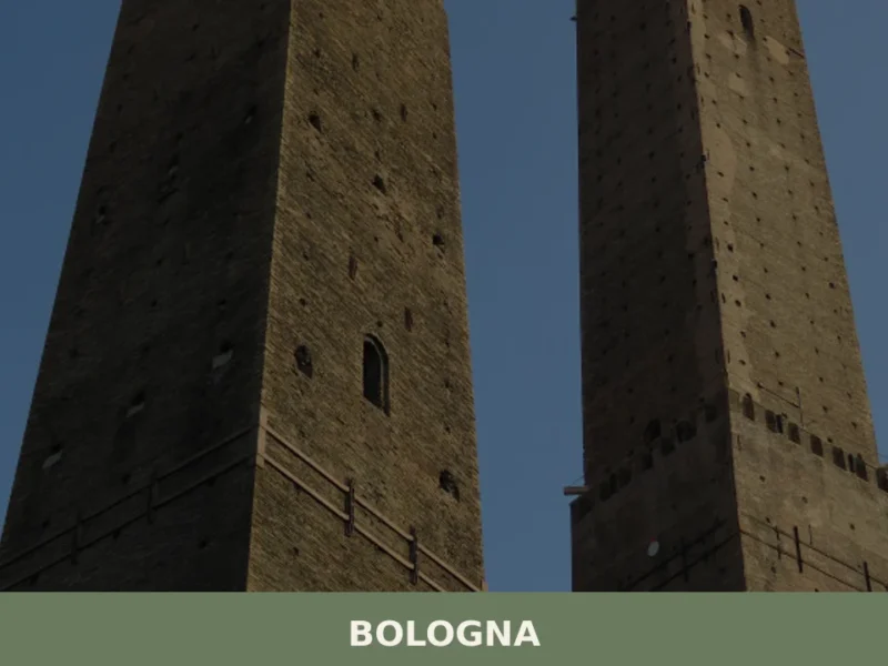
Bologna
What to see in Bologna: 388,000 inhabitants, UNESCO porticoes and the Two Towers. Plan your visit with our guide to tortellini, Mortadella IGP and top museums.
Farini
What to see in Farini, a village at 424 m in Val Nure with 1,043 residents: San Giuseppe Church, Apennine trails, PDO cured meats. Plan your visit and how to get there.
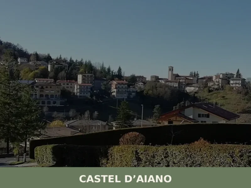
Castel d’Aiano
In 1944 the Gothic Line cut through these mountains, and Castel d’Aiano found itself at the centre of the clash between Allied forces and German troops: the hamlets of Villa d’Aiano, Sassomolare and Rocca di Roffeno still bear the marks of that period. Today the municipality has 1,916 inhabitants spread across a vast, hilly territory […]


📝 Incorrect information or updates?
Help us keep the Castel di Casio page accurate and up to date.