A medieval hill village at 456 metres above the Tavoliere plain, Pietramontecorvino preserves a rock-carved old quarter, Norman tower, and the quiet rhythms of Daunia’s agricultural past.
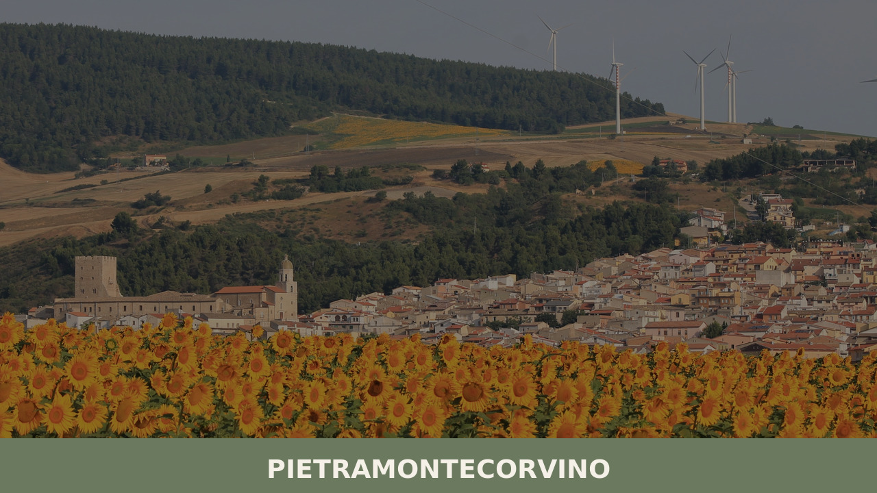
Morning light catches the limestone walls of the Terravecchia quarter before it reaches the valley floor. Roosters answer each other across tiled rooftops. An elderly man opens wooden shutters that have been repainted so many times the hinges sit in small mounds of enamel. Below, the Tavoliere plain stretches flat and pale toward the Adriatic. This is Pietramontecorvino — a village of 2,460 people at 456 metres above sea level in the province of Foggia — and the question of what to see in Pietramontecorvino begins here, in this old quarter, where the stone itself tells the story.
The name carries its own archaeology. “Pietra” refers to the rocky spur on which the original settlement was built; “Montecorvino” recalls the nearby ancient town of Montecorvino, a once-significant Norman bishopric that declined over centuries due to earthquakes and shifting populations. Refugees from Montecorvino gradually consolidated around the rocky outcrop, merging their identity with the stone that sheltered them. By the medieval period, the settlement had become a defined borgo with defensive walls, a ducal tower, and a church anchored into the living rock.
Under Norman rule in the 11th and 12th centuries, the area gained strategic importance along the routes connecting the Capitanata region to the rest of southern Italy. The village passed through Swabian, Angevin, and Aragonese hands — each leaving administrative marks if not always architectural ones. Frederick II’s reorganisation of Puglia in the 13th century placed the Capitanata’s hill towns, including Pietramontecorvino, within a network of imperial control stretching from Lucera to Foggia.
What survived the centuries most visibly is the Terravecchia, the old quarter. Its layout is distinctly medieval: narrow lanes designed for foot traffic and defense, houses built directly into and on top of the rock, and a civic geometry that follows the terrain rather than imposing a grid upon it. The village remained largely agricultural through the modern period, its population sustained by grain, olives, and sheep — the same economy that defined the Tavoliere for a thousand years.
The oldest part of the village is carved into and built upon a rocky ridge. Houses share walls with the stone itself — some rooms are half-cave, half-masonry. The lanes are steep, sometimes stepped, and narrow enough that neighbours on opposite sides could pass objects through facing windows. It is not a ruin; people still live here, and laundry still hangs between the medieval walls.
A square watchtower rises above the Terravecchia, likely dating to the 12th century. Its construction is robust, functional — thick walls with small openings designed for observation and defense, not decoration. The tower anchored the village’s original fortifications and today serves as the most recognisable vertical element in the skyline when approaching from the plain below.
Adjacent to the tower, the palazzo was the administrative seat for the feudal lords who governed the village across several centuries. The structure has been modified repeatedly, with Renaissance-era additions layered over medieval foundations. Its courtyard and façade show the transition from military architecture to residential display that marks many southern Italian feudal residences.
The principal church anchors the upper part of the village. Its Romanesque bones are visible despite later Baroque interventions — a common pattern across the Capitanata. Inside, the nave retains a sense of proportion and restraint. The church’s position, elevated and visible from multiple approaches, reflects its dual role as spiritual centre and civic landmark within the medieval settlement.
From the edges of the village, particularly near the Terravecchia, the view opens across the Tavoliere delle Puglie — the largest plain in southern Italy. On clear days the perspective extends toward the Gargano promontory to the east and the Subappennino Dauno ridgeline to the west. The surrounding landscape of wheat fields, olive groves, and scattered farmhouses has changed less than one might expect.
The cooking here is rooted in the pastoral and agricultural traditions of the Daunia hills. Bread is central — large, dense loaves made from local durum wheat, baked in wood-fired ovens, with a thick crust that stays edible for days. Orecchiette and cavatelli appear on most tables, dressed with simple vegetable sauces — turnip tops, wild chicory, or slow-cooked tomato with a scrap of dried chilli. Lamb and kid goat are prepared for feast days, often roasted with potatoes and wild herbs gathered from the surrounding slopes. Puglia’s extra-virgin olive oil — some of it carrying the Dauno DOP designation — is the foundational fat in everything.
Local cheeses include caciocavallo and scamorza, produced from the milk of cattle and sheep grazing the Subappennino pastures. In autumn, preserved vegetables — sun-dried tomatoes, marinated aubergines, pickled peppers — fill pantry shelves and appear as antipasti. Dining options in Pietramontecorvino are modest in number but tend toward family-run trattorias where the menu reflects whatever the season and the kitchen garden dictate. The wine is typically robust and red, drawn from the broader Foggia province’s vineyards.
Spring — late April through June — offers the most comfortable conditions. Temperatures at 456 metres are milder than on the Tavoliere floor, and the surrounding hillsides green up with wildflowers and new wheat. Autumn, from September into early November, is equally good: the harvest season brings activity to the countryside, the light turns golden and low, and the summer crowds (modest as they are in this part of Puglia) have gone. Summer can be hot, though the elevation provides some relief from the oppressive heat of the plain. Winter is cold and occasionally wet, with the Subappennino catching weather from the west.
The village’s patron saint festival and other local feast days — typically held in summer — bring processions, temporary food stalls, and evening gatherings in the main piazza. These events are organised for residents rather than visitors, which gives them an unperformed quality that is increasingly rare. Check with the Comune di Pietramontecorvino for specific dates, as schedules can shift from year to year.
Pietramontecorvino lies in the hills west of Foggia, the provincial capital. By car, the village is approximately 40 kilometres from Foggia, reachable via the SS17 and then local roads climbing into the Subappennino Dauno. From the A14 Adriatic motorway, exit at Foggia and follow signs toward Lucera, then continue northwest into the hills. The drive from Foggia takes roughly 45 minutes; from Bari, expect around two hours.
The nearest airport is Bari Karol Wojtyła (BRI), about 170 kilometres to the southeast. Foggia has a train station on the main Adriatic line, with connections to Bari, Naples, and Rome, but from Foggia to Pietramontecorvino you will need a car — public bus services exist but are infrequent and designed around school and commuter schedules rather than tourism. Renting a car in Bari or Foggia is the most practical option for reaching the hill villages of the Daunia.
Pietramontecorvino does not exist in isolation. The Subappennino Dauno is lined with small hill settlements, each shaped by the same geological and historical forces — Norman towers, medieval quarters, agricultural economies tied to wheat and sheep. Traveling northeast from Pietramontecorvino, Casalnuovo Monterotaro occupies a similar position along the ridgeline, offering its own medieval core and views over the northern Tavoliere. The two villages share a quiet, unhurried character that rewards slow exploration on foot.
Further east and down onto the plain, Cerignola presents a different scale and story — a larger agricultural town that became one of the centres of Puglia’s grain and wine production. Visiting both the hill villages and the plain towns gives a more complete picture of how geography shaped settlement in the Capitanata: the heights for defense and grazing, the lowlands for intensive cultivation. Together, they form a landscape that has operated as a single system for centuries.
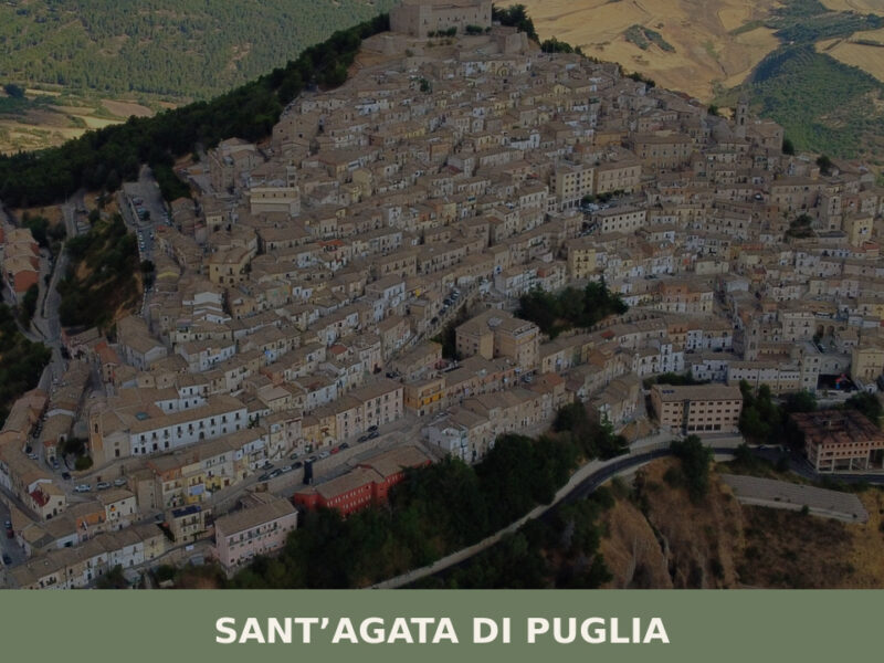
A ridge-top village at 794 metres in the Daunia hills, Sant'Agata di Puglia rewards slow exploration with its Norman castle, stepped stone alleyways, and mountain cooking.
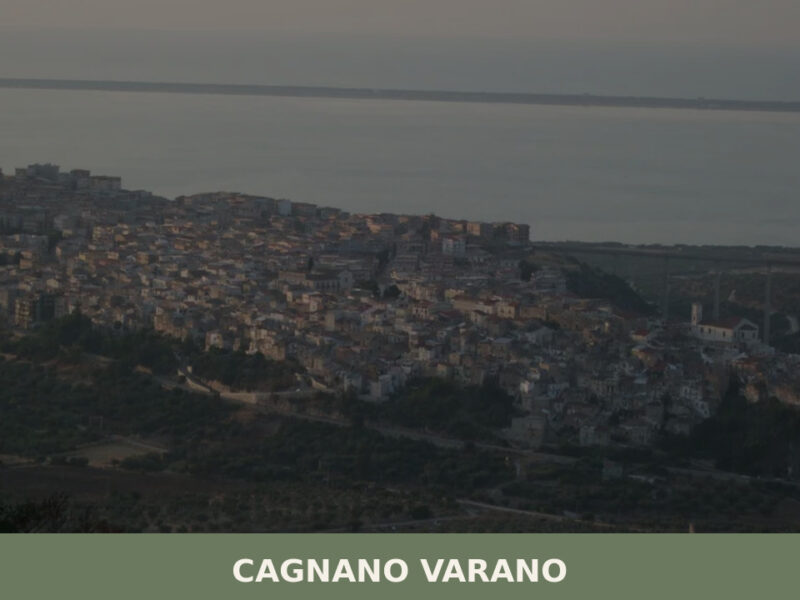
Discover Cagnano Varano, a quiet Gargano village overlooking Italy's largest southern lagoon. Explore ancient caves, lakeside trails, and authentic Puglian flavours.
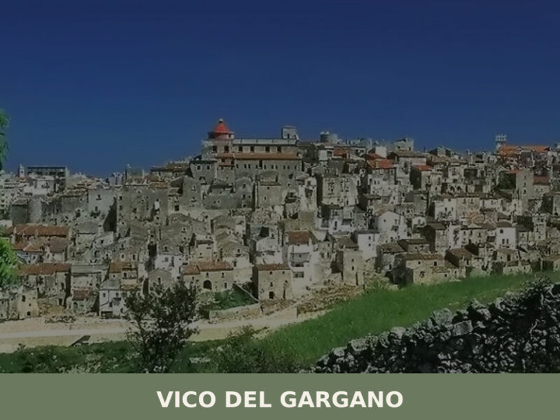
A hilltop village at 445 metres on the Gargano promontory, Vico del Gargano rewards slow exploration — medieval alleys, underground olive presses, and ancient forest at its edge.
📝 Incorrect information or updates?
Help us keep the Pietramontecorvino page accurate and up to date.
