
Fontanelice
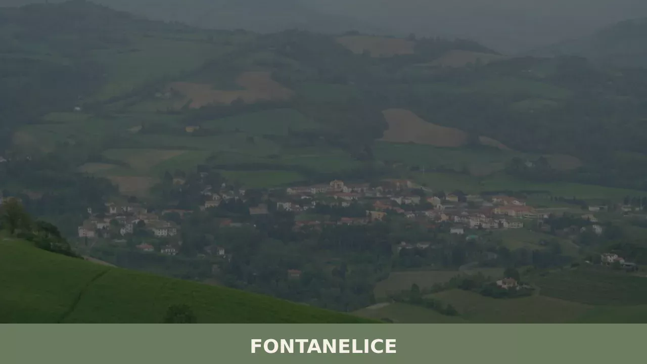
The provincial road climbing the Santerno valley passes through Imola and, after a few kilometres, reaches a compact settlement along the right bank of the river: this is Fontanelice, a municipality of 1,951 inhabitants at 165 metres above sea level, in the province of Bologna. The very name of the village refers to water — […]
Discover Fontanelice
The provincial road climbing the Santerno valley passes through Imola and, after a few kilometres, reaches a compact settlement along the right bank of the river: this is Fontanelice, a municipality of 1,951 inhabitants at 165 metres above sea level, in the province of Bologna. The very name of the village refers to water — the springs that once flowed abundantly from the clay soil — and to an evergreen oak, the holm oak (elce), which once marked the local landscape.
Asking what to see in Fontanelice means exploring a territory where Apennine geology, a border history between Romagna and Tuscany, and a still-active agricultural tradition converge in a catalogue of signs legible to those who know how to look.
History and origins of Fontanelice
The place name Fontanelice appears in medieval sources with several variants — Fontana Ilicis, Fons Ilicis — and its most widely accepted etymology traces it back to a spring (fons, fontana) located near a holm oak (ilex), an evergreen tree still common on the sun-facing slopes of the lower Santerno valley. The association between a water source and a recognisable plant element in the landscape was a standard criterion in early medieval place-naming across the Emilian-Romagnol Apennines. The botanical reference confirms the presence, as early as the Early Middle Ages, of mixed woodland cover in which the holm oak grew alongside deciduous oaks and chestnuts, marking the climatic boundary between the Po Plain and the sub-Mediterranean zone.
The village fell within the orbit of the municipality of Imola and, from the 13th century onwards, followed the fortunes of the Romagnol lordships. The territory was disputed between the Alidosi family — originally from nearby Castel del Rio — and the Manfredi of Faenza, before passing under the direct control of the Papal States during the 16th century.
In 1504, with the definitive subjugation of the Alidosi, the entire Santerno valley came under papal administration, a condition that lasted until the Unification of Italy in 1861. Its position along the route connecting the Po Plain to Tuscany via the Futa Pass gave Fontanelice a role as a transit point for goods and troops, a role that proved devastating during the Second World War, when the Gothic Line ran across the surrounding hills and the village suffered Allied bombing between the autumn of 1944 and the spring of 1945.
Post-war reconstruction reshaped part of the built fabric but did not erase the oldest structures. The population, which in the mid-19th century exceeded three thousand thanks to the sharecropping economy, experienced a steady decline linked to the rural exodus of the 1950s and 1960s. The current 1,951 residents represent a demographic stabilisation reflecting the transformation of the Santerno valley from a predominantly agricultural area to a territory where fruit growing, small-scale industry and a growing interest in rural tourism coexist. Among the notable names linked to Fontanelice is the painter Giovanni Battista Bertucci the Younger, active in the 16th century and associated with the Imola school of painting, whose family had roots in the valley.
What to see in Fontanelice: 5 essential attractions
1. Church of the Nativity of the Blessed Virgin Mary
The parish church, dedicated to the Nativity of Mary — patron saint of Fontanelice, celebrated on 8 September — dominates the village centre with its brick façade, rebuilt after the war damage of 1944. The single-nave interior retains 18th-century liturgical furnishings and a spatial layout typical of rural churches in the Diocese of Imola. The post-war reconstruction preserved the original plan while adapting it to modern structural requirements. It is worth visiting to observe the relationship between the sacred building and the square in front of it, the focal point of civic life in the village, where the weekly market is still held and the patron saint’s feast is celebrated with a procession and market stalls.
2. Palazzo Mengoni
Palazzo Mengoni is the most significant civic building in the historic centre, constructed between the 17th and 18th centuries as the residence of a local landowning family. The structure features a restrained façade with a sandstone portal and windows framed by terracotta mouldings, following the architectural language common to villages of the lower Santerno valley.
The interiors, remodelled during the 19th century, retain traces of tempera painted decorations in the rooms of the piano nobile. The building reflects the social stratification of the village during the papal era, when a small landed elite managed relations with the surrounding sharecropping system. The exterior can be viewed freely and provides a concrete reference point for understanding civic architecture in the Imola area.
3. Bridge over the Sellustra stream
The bridge over the Sellustra, a right-bank tributary of the Santerno, is a masonry structure connecting the core of Fontanelice with the hillside hamlets. Its construction dates to the period between the 18th and 19th centuries, when the papal administration invested in improving the valley’s road network. The round arch, built from blocks of local sandstone, withstands the flood patterns typical of Apennine torrents. The spot is popular with those walking the hiking trails along the watercourse, and during low-water seasons the Sellustra’s riverbed reveals clay geological formations of considerable interest. From here, a view opens onto the surrounding countryside that clearly shows the valley’s settlement pattern: scattered farmhouses, rows of vines, and orchards.
4. Oratory of San Procolo
Just outside the village centre, the Oratory of San Procolo is one of the best-preserved minor religious buildings in the area. Probably built in the 17th century as a votive chapel along one of the farm roads climbing towards the hills, it has modest dimensions, a semicircular apse and a small bell gable. The dedication to San Procolo — a Bolognese martyr venerated throughout Romagna — confirms the devotional link between Fontanelice and the hagiographic tradition of the diocese. The interior, normally closed to the public but accessible during religious festivals, contains a stucco altar and a stone holy water font. The oratory can be reached with a short walk from the village, suitable for families as well.
5. Trail along the Santerno river
Those wondering what to see in Fontanelice beyond the historic buildings will find an answer along the banks of the Santerno. A pedestrian and cycling path, partly unpaved, follows the river downstream and upstream of the village for several kilometres, passing through riparian woodland of willow and poplar. The route allows observation of river birdlife — grey herons, kingfishers, little egrets — and the geological formations along the banks, where grey-blue Pliocene clays are exposed. In spring and autumn the trail offers ideal conditions for hiking or cycling.
The path connects to the wider trail network of the Santerno valley, which climbs towards Castel del Rio and the Tuscan-Romagnol Apennine ridge.
What to eat in Fontanelice: local cuisine and regional products
The cuisine of Fontanelice belongs to the gastronomic tradition of the Apennine Romagna, a repertoire that differs from coastal Romagna through a stronger reliance on pork, mushrooms, chestnuts and handmade fresh pasta. Its position in the Santerno valley, a transitional area between the plain and the Tuscan-Emilian ridge, has produced a table where Bolognese and Romagnol influences coexist: ragù appears alongside piada, tortellini share the menu with strozzapreti. The availability of running water and the configuration of the terrain favoured the cultivation of soft wheat, vegetables and fruit trees for centuries, while the hillside woods supplied game, firewood and porcini mushrooms.
Among the dishes that define this area, tagliatelle al ragù stand out, prepared with a sheet of pasta rolled by hand with a rolling pin — an operation that in local tradition requires eggs from farmyard-raised hens and soft wheat flour — dressed with a beef and pork ragù slow-cooked with a soffritto of celery, carrot and onion. Strozzapreti, a pasta made with water and flour without eggs, hand-rolled and dressed with sausage sauce or porcini mushrooms, are the most common format in the valley’s trattorias. In winter, polenta appears, served with ragù or wild boar sauce, a legacy of a peasant diet in which maize supplemented the cereal intake during the cold months.
The Santerno valley falls within the production area of several recognised Emilia-Romagna products, although Fontanelice does not boast any specific certified productions of its own.
Extra virgin olive oil is produced on the surrounding hills, where small olive groves survive at the northern limit of olive cultivation in Italy. According to information documented on Wikipedia, the municipality sits within an agricultural context where fruit growing — particularly apricots, peaches and cherries — has partly replaced the traditional cereal-based sharecropping system. Acacia and chestnut honey is another widely available product, thanks to the proximity of Apennine woodlands that provide abundant blooms between May and July.
The main gastronomic event coincides with the patron saint’s feast on 8 September, when stalls selling local products, fresh pasta, cured meats and cheeses from the valley are set up in the village square. During autumn, festivals dedicated to porcini mushrooms and chestnuts enliven the neighbouring municipalities of the Santerno valley — Borgo Tossignano, Castel del Rio — and offer a practical opportunity to taste local dishes in a convivial setting.
For direct purchases, farms along the provincial road sell seasonal fruit and artisanal preserves, while in Imola, fifteen kilometres away, weekly farmers’ markets are held.
On the wine front, the area falls within the Emilia-Romagna wine region and specifically within the production zone of Sangiovese, the dominant red grape variety in Romagna. The vineyards of the lower Imola hills produce a Sangiovese di Romagna with a fruity, tannic profile, well suited to accompany ragù and grilled meats. Albana, the first Italian white wine to receive DOCG status in 1987, is grown in the hills between Imola and Faenza and can be found in the area’s wine bars and restaurants. Trebbiano romagnolo is also present, an everyday white wine that traditionally accompanied the sharecroppers’ meals.
When to visit Fontanelice: the best time of year
Spring, from April to June, is the most suitable period to visit Fontanelice. The blossoming of the fruit orchards in the Santerno valley transforms the landscape into a sweep of white and pink, temperatures range between 15 and 25 degrees, and the trails along the river are easily walkable. The patron saint’s feast of the Nativity of Mary, on 8 September, is the moment of greatest vitality in the village: a religious procession, market stalls, music and food draw residents and visitors from the surrounding areas. Autumn, between October and November, offers the advantage of the Apennine woodland colours and the mushroom and chestnut festivals held in nearby municipalities.
Summer can be hot and humid in the valley — temperatures in July and August often exceed 30 degrees — but evenings are cooler than on the Po Plain.
Winter, mild thanks to the modest altitude of 165 metres, does not pose particular difficulties but reduces the range of events and outdoor activities. Those seeking quiet will find the ideal conditions on weekdays in March and October: the village follows its daily rhythm without crowds, restaurants operate regularly and prices at any agriturismo accommodation remain affordable. For those combining Fontanelice with a broader itinerary in the Santerno valley, a stay of two or three days allows for an unhurried exploration of the neighbouring villages as well.
How to reach Fontanelice
Fontanelice can be reached by car from the A14 Bologna–Ancona motorway, Imola exit, continuing for approximately 15 kilometres along the SP610 towards Castel del Rio–Firenzuola. From Bologna the total distance is around 50 kilometres, requiring 45–50 minutes of driving. From Florence, follow the Autostrada del Sole (A1) to the Firenzuola exit or take the Futa state road, crossing the Apennines to reach the Santerno valley from the Tuscan side — a journey of approximately 90 kilometres and one and a half hours of driving. The Municipality of Fontanelice website provides up-to-date information on local road conditions.
The nearest railway station is Imola, served by the Bologna–Ancona line with frequent regional trains — the Bologna–Imola journey takes approximately 25 minutes.
There is no direct rail connection from Imola to Fontanelice, but an intercity bus service operated by TPER links the two centres in approximately 20–25 minutes. The nearest airport is Bologna Guglielmo Marconi, approximately 60 kilometres away. For those travelling by bicycle, the SP610 carries moderate traffic and has a gentle gradient, making the Imola–Fontanelice stretch a reasonable cycling route.
Other villages to discover in Emilia-Romagna
The Santerno valley is not the only territory in Emilia-Romagna where small villages maintain a direct relationship between human settlement and the Apennine landscape. Those wishing to continue their exploration towards the Piacenza side can reach Zerba, the least populated municipality in the entire region, located in the upper Trebbia valley at over 800 metres of altitude.
Zerba offers a radically different setting from Fontanelice: true mountain terrain, pastures, silence, stone architecture. The journey from Fontanelice requires approximately two and a half hours by car across the Emilian plain, but the contrast between the two environments — the low Romagnol hills and the Ligurian-Piacenza Apennines — makes the comparison instructive for anyone wishing to understand the internal variety of the region.
In the same Piacenza area, Cerignale represents another example of a mountain village where the population has shrunk to just a few dozen permanent residents. Also located in the Trebbia valley, Cerignale shares with Fontanelice the condition of a municipality affected by depopulation, but in a more pronounced form: here the abandonment of the mountains has left rural settlements partly uninhabited, now the focus of restoration efforts by new residents and cultural associations.
An itinerary connecting Fontanelice, Zerba and Cerignale effectively crosses the whole of Emilia-Romagna from east to west, touching three provinces — Bologna, Piacenza — and three different altitude bands, offering a concrete synthesis of the geographical and human complexity of this region.
In Emilia-Romagna More villages to discover
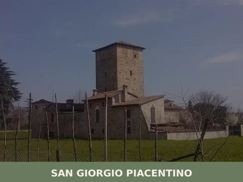
San Giorgio Piacentino
What to see in San Giorgio Piacentino: 5,533 residents at 103 m altitude, Renaissance villas, PDO cured meats, and the 23 April patron feast. Plan your visit now.
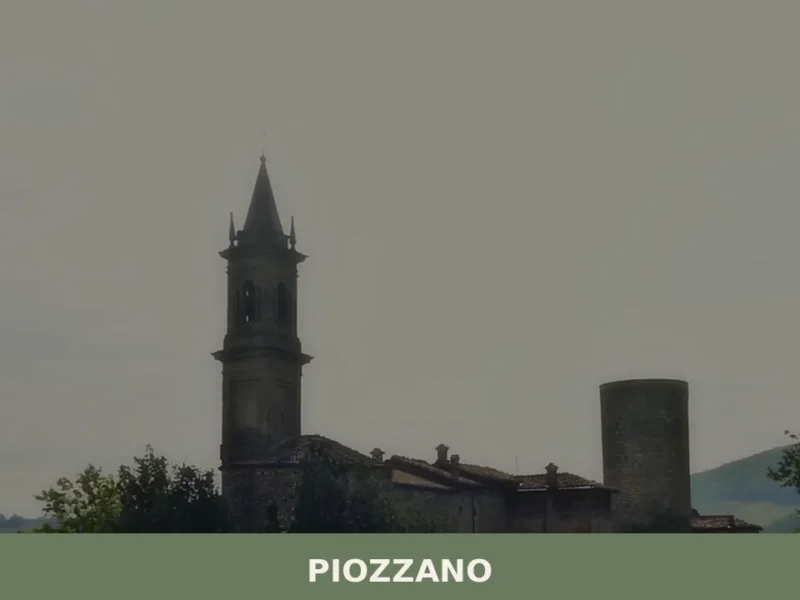
Piozzano
Piozzano, a village in Emilia-Romagna with 645 inhabitants, is situated at an elevation of 222 meters above sea level within the province of Piacenza. This location places it amidst the agricultural landscape of the Piacentine hills, where the transition from the Po Valley to the Apennine foothills is evident. For those considering what to see […]
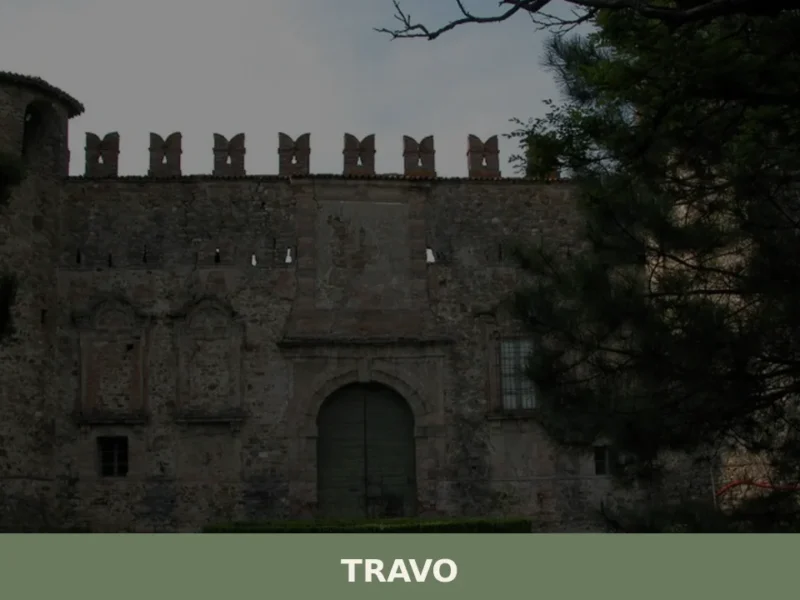
Travo
At 171 metres above sea level, in the lower Val Trebbia, Travo is one of those centres in the province of Piacenza where the historical layers of the past surface in visible, tangible ways: from pre-Roman foundations to the medieval domains of the Malaspina and Landi families, with traces of the Matildine Middle Ages in […]


📝 Incorrect information or updates?
Help us keep the Fontanelice page accurate and up to date.