Discover The agricultural landscape of the lower Valdarno in Cerreto Guidi: complete visitor guide
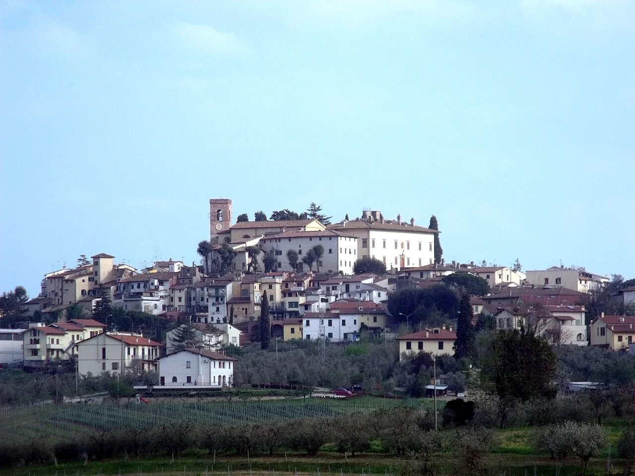
Standing at 123 metres above sea level on the edge of the lower Valdarno plain, Cerreto Guidi is a Florentine borough of roughly 10,488 inhabitants whose identity has been shaped as much by its Medici past as by the agricultural landscape that surrounds it on every side. The flat fields stretching towards Empoli and the Arno have fed this community for centuries, and understanding them is key to understanding the place itself. This guide focuses specifically on that rural dimension — the crops, the land tenure history, the seasonal rhythms — while placing them within the broader context of what makes Cerreto Guidi worth a deliberate visit rather than a passing glance.
The Agricultural Landscape of the Lower Valdarno: Geography and Formation
The agricultural landscape that opens up around Cerreto Guidi belongs to a distinct geographical unit: the lower Valdarno, the broad alluvial corridor through which the Arno makes its final approach from Florence towards Pisa and the Tyrrhenian coast. This is not hill-country Tuscany with its cypress rows and dramatic gradients. It is flat, wide and deliberately productive — a stretch of drained floodplain where the soils are deep, silty and generous to anyone willing to work them.
Geologically, the plain owes its character to thousands of years of Arno flooding. Each inundation deposited fresh alluvium, gradually building up the fertile layer that today supports cereal crops, sunflowers, market vegetables and the scattered remnants of mixed coltura promiscua — the traditional Tuscan system of interplanted vines, olives and field crops. Cerreto Guidi sits on a low rise at the northern edge of this plain, high enough to stay dry but low enough — just 123 metres — to remain intimately connected with the flat fields below. The municipality is classified seismically as zone 2 (medium-high seismicity, Ordinanza PCM 3274 of 20 March 2003), a reminder that this seemingly placid plain sits above tectonically active ground.
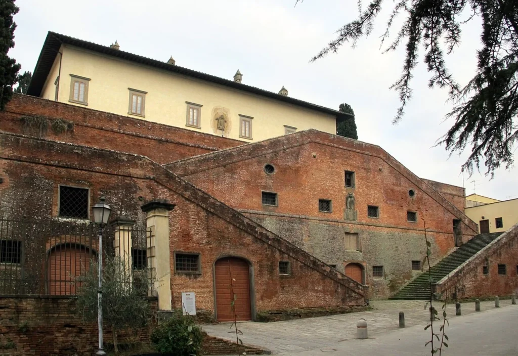
Looking south from the brick ramps of the Villa Medicea, the eye travels uninterrupted across the agricultural landscape of the lower Valdarno for kilometres. There are no significant natural obstacles between the village and the Arno. This visual continuity is not accidental: the Medici specifically valued the openness of this terrain, both for hunting and for the kind of systematic agrarian management that made their estates so profitable in the sixteenth century. What the modern visitor sees is therefore a landscape that has been consciously organised and reorganised over at least five centuries, and it repays close attention.
Mezzadria, Land Reform and the Fields You See Today
To understand why the agricultural landscape of the lower Valdarno looks as it does in the twenty-first century, it is necessary to spend a moment with the mezzadria — the sharecropping system that governed Tuscan rural life from the late medieval period until its legal abolition in 1982. Under mezzadria, a landowner provided the farmhouse (podere), the tools and the seed; the tenant family provided the labour and surrendered half of every harvest. The system was paternalistic, often exploitative, and extraordinarily effective at maintaining a densely populated, intensively cultivated countryside.
In the territory of Cerreto Guidi, mezzadria was the dominant form of land tenure from at least the fifteenth century. The Medici themselves were major landlords here, and their estates were divided into numbered poderi each worked by a single family. The farmhouses that dot the plain today — solid two-storey buildings in grey pietraserena or plastered brick, each with its colonnade of cypresses — are the physical residue of that system. After the Medici grand-duchy gave way to the House of Lorraine and eventually to unified Italy, the land passed through various aristocratic and bourgeois hands before the reforms of the 1950s and the definitive abolition of mezzadria began to transform the agricultural landscape irrevocably.
Post-reform consolidation meant that many small poderi were merged into larger mechanised holdings. Hedgerows came down, field boundaries shifted, and the interplanted coltura promiscua gave way to monoculture cereal strips. The process was less dramatic here than in some other parts of Tuscany — the plain was already relatively open — but it did erase much of the fine-grained texture that characterised the pre-war countryside. What survived are isolated farmhouses, the occasional remnant row of vines trained on alberi maestri (elm or mulberry standards), and the general proportions of a landscape still recognisably derived from its sharecropping past.
The 1860 plebiscite on Tuscany’s annexation to the Kingdom of Sardinia produced a curious local result in Cerreto Guidi: of the 1,731 eligible voters, the “yes” vote did not achieve a majority of those entitled to vote, owing to record-level abstentionism. Historians have linked this reluctance partly to the anxieties of a rural community — many of them mezzadri — uncertain about what unification would mean for their land rights. The agricultural landscape was, in other words, a political landscape too.
Vines, Olives and Market Gardens: What the Land Still Produces
The agricultural landscape of the lower Valdarno around Cerreto Guidi does not fall within any of Tuscany’s famous DOC or DOCG wine zones — it sits outside both the Chianti Classico territory to the east and the Montalbano zone to the north. This has historically made it less commercially visible but no less productive. Local farmers grow Sangiovese and Trebbiano for domestic consumption and small-scale sale, typically within the Indicazione Geografica Tipica (IGT) framework. Several agriturismo operations on the plain offer their own unlabelled house wine alongside meals, and the quality, while variable, reflects honest farming rather than brand management.
Olive groves persist on the slightly higher ground around the village itself, where the frost risk is lower than on the valley floor. The olives here tend to be late-harvested in November, pressed at one of the communal mills (frantoi) that still operate in the area, and sold locally. The resulting oil is typically robust and peppery — characteristic of low-altitude Tuscan production — though it lacks the altitude-driven intensity of oil from Fiesole or Impruneta.
On the plain proper, the predominant crops are sunflowers (highly visible in July, when the fields turn a uniform yellow visible from the village’s upper streets), maize, durum wheat and, increasingly, processing tomatoes — a crop that arrived in the Valdarno in the 1970s and 1980s as contract farming for industrial canneries became commercially attractive. Market gardens supplying the Empoli and Fucecchio markets are another feature of the agricultural landscape, concentrated near the irrigation channels that cross the plain.
- Sunflowers: dominant crop on the flat alluvial fields; harvested August–September
- Durum wheat: grown on consolidated holdings; harvested June–July
- Processing tomatoes: contract-farmed for industrial use; harvested late July–August
- Sangiovese and Trebbiano: small vineyard plots for local consumption and agriturismo
- Olive groves: concentrated on slightly elevated ground around the village; oil pressed in November
- Market vegetables: irrigated holdings near drainage channels; year-round production
This diversity is worth noting because it contradicts the common assumption that the Valdarno plain is purely a monoculture cereal zone. The agricultural landscape here is patchwork and varied, and a slow drive or cycle along the secondary roads south of the village — the Strada della Collina, the Via delle Fonti — reveals this variety far better than any overview from the hill.
The Medici Hunting Reserve and Its Influence on Rural Land Use
The most significant single intervention in the agricultural landscape of the lower Valdarno near Cerreto Guidi was not agricultural at all: it was the creation of a grand-ducal hunting reserve by Cosimo I de’ Medici between approximately 1555 and 1565. Cosimo chose this territory precisely because its mixture of open plain, reed-filled drainage channels, and residual woodland offered ideal conditions for the game he favoured — wild boar, deer, hare and waterfowl.
The reserve had practical consequences for the surrounding farmland. Certain areas were managed specifically to maintain habitat rather than maximise agricultural yield: woodland was preserved along the channels, wet areas were left undrained, and the density of agricultural settlement was kept deliberately lower than on comparable land elsewhere in the Florentine contado. This management logic left a legacy in the landscape that is still faintly legible today: the woodland remnants along the irrigation channels south-east of the village, the slightly lower density of farm buildings in the area closest to the old riserva boundaries, and the persistence of hunting culture in local life.
The Villa Medicea di Cerreto Guidi — now housing the Museo Storico della Caccia e del Territorio — stands as the architectural centrepiece of this intervention. Its celebrated brick ramps, designed as monumental access ramps rather than conventional stairs, were built under Cosimo I to allow horses to be led directly from the courtyard to the upper floor level, a functional requirement of a working hunting lodge as much as an architectural statement. The museum itself documents the history of hunting in Tuscany with a collection of firearms, hunting equipment and paintings that ranges across several centuries, and it provides the best contextual framework for understanding why the agricultural landscape around Cerreto Guidi was shaped differently from the purely agrarian countryside further east.
The villa is also classified as part of the broader UNESCO World Heritage Site of Medici Villas and Gardens in Tuscany — the same designation that covers Villa Medici at Careggi and other Florentine properties — though Cerreto Guidi’s rural setting gives it a character quite different from its more urbane counterparts near Florence.
Villa Medicea di Stabbia and the Agricultural Estates of the Plain
Cerreto Guidi’s territory contains a second Medici villa that receives considerably less attention than its famous counterpart on the hill: the Villa Medicea di Stabbia, located in the frazione of Stabbia in the flatlands to the south. Where the main villa is a hunting lodge elevated above the plain and oriented towards the landscape as spectacle, Stabbia is a working estate villa — a building type designed to oversee agricultural production directly from within the fields rather than from above them.
The Villa di Stabbia illustrates a different relationship with the agricultural landscape of the lower Valdarno: one of extraction and management rather than recreational appreciation. Estate villas of this type were the operational headquarters of the Medici’s agrarian economy in the region, and their design reflects that purpose — storage rooms for grain and oil occupy the ground floor, the administrative offices and owner’s apartments are above, and the entire ensemble is oriented towards the farmyard rather than a formal garden. The building survives, though it has undergone substantial modifications since the Medici period, and it is not regularly open to the public. It can, however, be observed from the road, and its presence in the flat terrain makes an instructive comparison with the hilltop villa.
Together, the two villas define a dual relationship with the landscape: the hilltop villa frames the agricultural plain as a view and a hunting ground; the plain villa embeds itself within it as a productive unit. Walking or cycling between them — a distance of roughly four kilometres along the secondary roads — is one of the more rewarding ways to experience the agricultural landscape of the lower Valdarno in its full depth.
Reading the Landscape on Foot: Routes Through the Valdarno Fields
The agricultural landscape of the lower Valdarno is best understood at walking or cycling pace, on the network of unpaved strade bianche and minor asphalted roads that cross the plain between Cerreto Guidi, Stabbia and the Arno. These routes carry almost no through traffic outside harvest season, and they pass through the full sequence of rural land-use types described above: consolidated cereal fields, isolated podere farmhouses, olive terraces, irrigation channels with their marginal reed beds, and occasional remnant patches of woodland.
A practical starting point is the Piazza Vittorio Emanuele II in Cerreto Guidi, from which the Via delle Fonti leads south-east past the historic water sources (the system of covered public fountains that once supplied the village) and then drops onto the plain. From here, several circuits of between five and twelve kilometres are possible without retracing steps. The longest loop reaches the Arno embankment near the confluence of a minor tributary, offering a view back towards the village’s low hill that clarifies the topographic logic of the whole settlement pattern.
The Pieve di San Leonardo, documented since the tenth century and substantially rebuilt under Cosimo I, sits within the village rather than on the plain, but its historical role as a territorial parish church — serving a scattered population of farmers across a wide rural zone — connects it directly to the agricultural landscape it once organised spiritually and administratively. Medieval parishes in Tuscany were the primary units of rural territory management long before municipal governments took over that function, and San Leonardo’s presence since at least the tenth century implies a well-established agrarian settlement in this part of the Valdarno at least a thousand years before the Medici arrived.
For visitors who prefer guided interpretation, the Museo Storico della Caccia e del Territorio occasionally organises territory walks led by local naturalists, typically in spring and autumn. Details are available through the municipality’s official website at comune.cerreto-guidi.fi.it — the same site that publishes weekly opening hours for the town hall (the summer 2026 schedule, for instance, specifies reduced hours for the week of 13–18 July).
Key Points on a Landscape Walk from Cerreto Guidi
- Historic water sources (fonti): covered stone fountains on the Via delle Fonti, dating from the early modern period, marking the transition from village to plain
- Remnant coltura promiscua: occasional rows of vines trained on standards, visible near older farmhouses south-east of the village
- Consolidated cereal fields: post-reform large-scale holdings; most extensive in the central plain between Cerreto Guidi and Stabbia
- Drainage channels: lined with willows and reeds; the widest date from land-reclamation works of the nineteenth century
- Villa Medicea di Stabbia: visible from the road approximately 4 km south of the village; the external architecture summarises the estate-management function of the agricultural plain
- Arno embankment: approximately 6–8 km from the village depending on route; offers the clearest view of the plain’s full extent
Seasonal Calendar: When to Visit for the Best Rural Experience
The agricultural landscape of the lower Valdarno changes dramatically across the seasons, and the timing of a visit significantly affects what a traveller will encounter. The following breakdown is based on the crop calendar described above and on the general climatic classification of Cerreto Guidi (zone D, 1,698 heating degree days, high atmospheric diffusivity per Ibimet CNR 2002 data), which places the area in a moderately continental variant of the Mediterranean climate — cold enough for hard frosts in January, hot and dry enough in July and August to stress unirrigated crops.
March–April is arguably the most varied period. Winter wheat is green and growing, olive groves are beginning to show new foliage, and the drainage channels carry maximum water from winter rains. The light is clear and relatively flat, ideal for photography of the landscape’s horizontal geometry. Temperatures are mild (10–18°C) and walking is comfortable.
May–June brings the wheat to its golden pre-harvest state. By late May, the fields south of the village are a colour range running from pale green through yellow to bronze, with poppies — a common weed of cereal fields throughout Tuscany — providing scattered red accents along the field margins. Wheat harvest typically begins in the second week of June and the combine harvesters working the consolidated fields are a significant feature of the landscape for about a fortnight.
July is the month of the sunflowers. The large-headed cultivars grown here for oil and birdseed face east in the morning and west in the afternoon, giving the fields a directional quality that changes with the light. It is also the hottest period, with temperatures regularly exceeding 35°C, making midday walking inadvisable. Early morning or late afternoon excursions are the practical solution.
October–November is olive harvest season. The groves around the village are worked by hand or with pneumatic rakes, the nets spread under the trees, and the smell of fresh-pressed oil carries from the frantoi. This is also when the agricultural landscape most clearly resembles its historical self — the pace of work, the tools and the social dynamics of harvest have changed less in olive cultivation than in any other sector of local agriculture.
December–February is the quietest period. The plain is brown or fallow, and the village itself slows to its winter rhythm. The Villa Medicea remains open (check current hours via the official website), and the absence of visitors makes this the best time to experience the museum collections without interruption.
Practical Information for Visiting Cerreto Guidi
Cerreto Guidi lies approximately 35 kilometres west of Florence along the Florence–Pisa–Livorno railway line. The nearest station is Empoli, about 8 kilometres to the south-east, from which local buses connect to the village. By car, the most direct approach from Florence is via the FI-PI-LI superstrada (SGC Florence–Pisa–Livorno), exiting at Empoli Est and following the SP11 northwards through the plain — a route that crosses the agricultural landscape before climbing to the village, providing an excellent introductory transect of the terrain.
The municipality issues ZTL (Limited Traffic Zone) permits for the historic centre; as of July 2026, these are collected during standard town hall opening hours. Summer 2026 opening hours show reduced access during mid-July, so visitors arriving by car should check the current schedule on the official website before planning a visit. The town hall address is in the centre of Cerreto Guidi, and the ZTL zone covers the immediate surroundings of the Villa Medicea.
The Museo Storico della Caccia e del Territorio inside the Villa Medicea is the primary paid attraction. Entry prices and opening hours vary seasonally; the museum is closed on Mondays. The Pieve di San Leonardo, the Oratorio della Santissima Trinità (which contains a notable Counter-Reformation panel painting attributed to Passignano, depicting the Communion of Santa Liberata), and the Santuario di Santa Liberata — a sanctuary that grew up in the fourteenth century around a fresco of the saint — are all accessible at no charge during normal hours.
For accommodation, the most practical options are agriturismo farms on the plain, which combine proximity to the agricultural landscape with direct access to local food production. Several operate between Cerreto Guidi and Stabbia. Empoli offers a wider range of hotels and is viable as a base for day visits. Cerreto Guidi itself has limited accommodation infrastructure, as the borough has developed neither as a mass-tourism destination nor as an agriturismo hub on the scale of the Chianti zone.
Getting Around the Agricultural Plain
- By bicycle: the flat terrain makes cycling the most efficient way to explore the agricultural landscape; no dedicated cycle infrastructure exists, but traffic on secondary roads is minimal outside harvest season
- By car: secondary roads (strade provinciali and strade comunali) cross the plain in a loose grid; parking is unrestricted outside the ZTL zone
- On foot: the strade bianche network is walkable year-round; good walking shoes rather than hiking boots are sufficient given the flat terrain
- Public transport: buses from Empoli station serve Cerreto Guidi village but do not penetrate the rural plain; local exploration requires private transport
The borough’s twin-town relationships with Saint Marcel (France) and Pianello Val Tidone (Piacenza province, Emilia-Romagna) reflect the municipality’s interest in maintaining rural and agricultural connections beyond its immediate Florentine context. Pianello Val Tidone in particular is another small agricultural community in a river-valley setting, and the twinning reflects a recognition that the challenges and identities of such places have more in common across regional boundaries than is often acknowledged.
A final practical note on the coat of arms: the municipality’s emblem, granted by presidential decree on 8 November 1993 but derived from a seal documented as far back as the fourteenth century, features the cerro oak — the species that gave the village its name and that once covered the hills above the plain before agricultural clearance transformed the landscape over many centuries. The gonfalone (civic banner) is divided vertically in yellow and green — colours that, in a landscape reading, might easily represent the fields of ripe wheat and the irrigated market gardens of the plain below.
FAQ: What Visitors Most Often Ask About Cerreto Guidi
What exactly is the agricultural landscape of the lower Valdarno?
The lower Valdarno is the alluvial plain through which the Arno flows between Pontassieve (east of Florence) and Empoli, gradually widening as it approaches the sea. The agricultural landscape of this zone is characterised by deep, fertile soils deposited by millennia of flooding, a predominantly flat topography, and a land-use history that includes Medici estate management, mezzadria sharecropping and post-reform mechanisation. Around Cerreto Guidi, this landscape is visible immediately south of the village, extending towards Empoli and the Arno embankment.
Is Cerreto Guidi within a wine DOC or DOCG zone?
No. Cerreto Guidi falls outside the principal Tuscan wine appellations. Local wine production exists but operates largely under the IGT (Indicazione Geografica Tipica) designation or is sold directly by farms without formal classification. Visitors looking for wines with established appellations would need to travel east towards Montespertoli (Chianti DOCG) or south-west towards San Miniato and the broader Chianti delle Colline Pisane zone.
Can I visit the Villa Medicea di Stabbia?
The Villa Medicea di Stabbia is not regularly open to the public. It is privately owned or managed and can be seen from the public road. For the main Villa Medicea di Cerreto Guidi and its museum, visits are possible during published opening hours (closed Mondays; check current schedule at comune.cerreto-guidi.fi.it as hours vary seasonally).
How long does it take to see Cerreto Guidi?
The village centre and its principal monuments — the Villa Medicea, the Pieve di San Leonardo, the Santuario di Santa Liberata and the historic water sources — can be covered in half a day at a comfortable pace. Visitors who wish to explore the agricultural landscape on foot or by bicycle would benefit from a full day, and those staying at an agriturismo in the area could easily fill two days without exhausting what the territory has to offer.
What is the best time of year to see the agricultural landscape?
Each season offers a distinct character. May and June provide the wheat fields at their most photogenic, with poppies along the margins. July is sunflower season but extremely hot. October–November offers the olive harvest, which remains the most historically continuous agricultural activity in the area. March and April combine green crops with the best walking temperatures. December–February is the quietest period, best for museum visits rather than landscape exploration.
Is there a connection between the Villa Medicea and the surrounding farmland?
Yes, directly. Cosimo I de’ Medici built the villa between approximately 1555 and 1565 specifically to serve as a hunting lodge for the surrounding reserved territory. The management of that reserve shaped land use across the plain for two centuries, maintaining woodland cover and wetland habitat in areas that might otherwise have been fully converted to agriculture. The Museo Storico della Caccia e del Territorio inside the villa documents this relationship between the ducal residence and the working landscape around it.
Are there organised agriturismo experiences near Cerreto Guidi?
Several agriturismo farms operate between Cerreto Guidi and Stabbia, offering accommodation and meals based on local produce. Specific availability and booking conditions change annually; the municipality’s official website and regional agriturismo listings are the most reliable sources of current information. The experience typically includes locally pressed olive oil, house wine, and seasonal vegetables from the agricultural landscape immediately surrounding the property.
How does Cerreto Guidi’s Chinese community relate to the agricultural economy?
According to ISTAT data from 31 December 2010, the largest foreign resident group in Cerreto Guidi was Chinese (814 people, 7.59% of the population), followed by Albanian residents (214 people, 2%). This demographic pattern is characteristic of the lower Valdarno and Empoli basin more broadly, where Chinese-owned textile manufacturing — rather than agriculture — has been the primary driver of immigration since the 1990s. The agricultural landscape and the industrial textile economy occupy the same geographic space but largely separate economic worlds within this territory.