The Francigena Way stage at Aulla is one of the most historically documented stops on the entire pilgrimage route from Canterbury to Rome — a fact recorded in writing as early as 990 AD, when Archbishop Sigeric of Canterbury noted the settlement in his travel diary on his return from the Eternal City. Aulla itself is a town of roughly 11,274 inhabitants in the Lunigiana district of northern Tuscany, sitting at the confluence of the Aulella torrent and the Magra river, at an elevation of just 64 metres above sea level. What follows is a detailed guide to this Francigena Way stage: its medieval layers, its monuments, its practical logistics, and the specific reasons it still matters to pilgrims and curious travellers alike.
Sigeric’s Diary and the Birth of a Pilgrimage Stop
The written record that anchors Aulla to the Via Francigena is remarkably precise. In 990 AD, Sigeric — newly consecrated Archbishop of Canterbury — walked from Rome back to England and kept a travel journal that survives to this day. In it, he listed 79 overnight stops, and among them he recorded a locality he called Aguilla. Scholars have consistently identified this as the modern town of Aulla. Depending on which numbering convention one uses, Aulla appears as either the 28th or 30th stage of the route — the discrepancy arises from different methods of counting the Roman stages — but the identification itself is not disputed.
This single document transformed what might otherwise be a footnote in Lunigiana’s administrative history into one of the most referenced Francigena Way stages on the Italian stretch of the route. Sigeric’s itinerary is the oldest surviving continuous description of the road between Rome and the Alps, and it became the template against which modern attempts to reconstruct the pilgrimage path have been calibrated. The name Aguilla is one of several medieval variants recorded for the settlement: documents from the same era also use Aula, Auula, Avula, Ula and Vulla, reflecting the phonetic instability of a place that sat at the boundary between Ligurian and Tuscan linguistic spheres.
The etymological debate about the name is itself telling. A recent interpretation, drawing on the dialectological work of Stefano Poggi, proposes that the root is the ancient Ligurian word ula, meaning “forest” or “woodland”, preceded by a feminine article a that eventually fused into the toponym. If accurate, this suggests that the medieval pilgrims stopping at Aguilla were resting in a place that locals had long associated with dense woodland — a landscape radically different from the built-up valley floor visible today. An earlier documentary trace appears in 884 AD, when Marquis Adalberto I of Tuscany referred to the area in a diploma using the phrase inter flumen Macrae et Aulae — “between the rivers Magra and Aulla” — confirming that the toponym was already fixed before Sigeric arrived a century later.
The Geography That Made Aulla Unavoidable
Understanding why Aulla became a Francigena Way stage requires a brief look at the physical map. The town sits at precisely the point where the valley of the Magra narrows sharply, compressed between the Apennine foothills on one side and the hills of the Lunigiana on the other. North of this bottleneck, the valley opens towards the Po plain and the Alpine passes; south, it descends towards the Ligurian coast and the ancient port of Luni. Anyone travelling between northern Europe and Rome who chose the inland route through Tuscany — rather than the coastal Ligurian road — had to pass through this bottleneck. There was simply no practical alternative.
This geographic compulsion is still visible in the modern infrastructure layered over the medieval road. The A15 motorway connecting Parma to La Spezia runs directly through Aulla’s outskirts. Two national roads — the SS 62 towards the Passo della Cisa and the SS 63 towards the Valico del Cerreto — converge here. Two railway lines meet at Aulla station: the Parma–La Spezia line and the Lucca–Aulla line, also known as the Garfagnana railway, which threads up through the Garfagnana valley before joining the main line here. Medieval pilgrims travelling the Francigena Way stage were, in a sense, using the same logic as modern infrastructure planners: Aulla is where the routes meet because the terrain insists upon it.
The confluence of the Aulella torrent and the Magra river — still clearly visible and photographed extensively — was not only a geographic marker but a practical one. Medieval travellers needed water, and this confluence provided it reliably. It also created the low-lying alluvial land on which the town’s historic core developed, a fact that would prove catastrophic in January 2011. The climate consequences of this valley position are also worth noting: in winter, morning fog is almost constant, trapped by the surrounding hills; in summer, the combination of heat and high humidity makes the town one of the more uncomfortable spots in northern Tuscany during July and August — useful information for anyone planning to walk the Francigena Way stage here in the warmer months.
Before the medieval pilgrimage trade, the Romans had already recognised the strategic value of this junction. Aulla was a Roman settlement, and one of the major roads of the ancient world — the so-called strada delle cento miglia, the “road of a hundred miles” — ran from the port of Luni through this territory towards Parma, passing through what is now the Passo del Lagastrello (historically known as the Malpasso). The Via Francigena, centuries later, followed a similar logic, threading the same natural corridors through the Apennines.
The Abbazia di San Caprasio: Founding Monument of the Stage
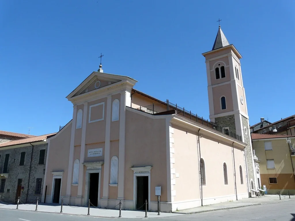
The monument most directly associated with the Francigena Way stage at Aulla is the Abbazia di San Caprasio. Its founding date is recorded with unusual precision: 884 AD, the same year as the diploma of Adalberto I of Tuscany that first documents the toponym of Aulla. The abbey was built at the confluence of the Magra and the Aulella, and its establishment transformed what had been a modest valley settlement into an organised stopping point for travellers and pilgrims. The Obertenghi marquises — precursors to the Malaspina dynasty that would later dominate the Lunigiana — are credited with founding or at least endowing the abbey.
The structure visible today has been modified many times over the subsequent eleven centuries, but the core of the Romanesque building survived into the modern era. What changed dramatically was the understanding of its contents. In 2001, during excavation works inside the abbey, archaeologists discovered a reliquary box attributed to San Caprasio himself. This was not a minor find: reliquaries of this type — typically small, ornate containers holding bone fragments or cloth associated with a saint — were the primary reason pilgrims would detour to specific churches in the first place. The discovery confirmed that the abbey had been, from its earliest years, not merely a travellers’ hostel but a place of active cult veneration. The reliquary is now displayed in the museum annexed to the church, and it remains the single most important artefact directly connected to the medieval Francigena Way stage at Aulla.
The flood of January 2011 caused severe damage to the abbey’s structure and its surroundings. The subsequent restoration works were lengthy and, in several respects, archaeologically productive: they exposed earlier building phases and clarified the evolution of the complex from its Carolingian-era foundation through its later medieval expansions. For visitors approaching Aulla specifically to understand the Francigena Way stage, the abbey and its small museum represent the most concentrated single site — a place where the documentary evidence, the physical architecture and the material culture of medieval pilgrimage converge in one location.
The Fortezza della Brunella and the Malaspina Legacy
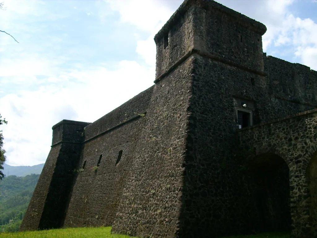
on a rocky spur above the confluence of the two rivers, the Fortezza della Brunella is the dominant visual element of the Aulla skyline and one of the most discussed monuments in any account of the town’s later medieval history. Its construction is associated with the Malaspina family, the feudal dynasty that controlled much of the Lunigiana from the 12th century onwards, though the current structure dates primarily from the late 15th and early 16th centuries. The building sits on precisely the vantage point that made Aulla worth controlling: from the fortress, one can observe both river valleys simultaneously and monitor all traffic passing through the bottleneck.
The Malaspina connection to the Francigena Way stage is not incidental. The family’s power was built partly on the revenues generated by pilgrimage traffic — tolls, hospitality fees, the economic activity that a steady flow of travellers through a controlled pass invariably generates. Dante Alighieri, who spent time in the Lunigiana as a political exile in the early 14th century, is known to have been received by the Malaspina and wrote about them; his presence in the region is a useful indicator of the cultural weight the family carried at the height of their power.
In 1522, a more dramatic episode disrupted the Malaspina hold on Aulla. Giovanni de’ Medici — the condottiere known to history as Giovanni delle Bande Nere, one of the last great mercenary captains of Renaissance Italy — purchased the fief of Aulla from the Malaspina. His intention was to carve out an independent personal state in northern Tuscany. He commissioned further fortification works on the Brunella, but his ambitions were cut short: Giovanni delle Bande Nere died in 1526 from wounds received in battle near Mantua, and his project for an Aulla-based lordship died with him. The fief subsequently passed to the Centurione, a prominent Genoese banking family, before being absorbed into the Grand Duchy of Tuscany in the 18th century.
Today the Fortezza della Brunella houses the Museo di Storia Naturale della Lunigiana, a natural history museum that, somewhat surprisingly given its military shell, has become one of the more visited institutions in the province of Massa-Carrara. The juxtaposition of a Renaissance fortress and a natural history collection is unusual, but the building’s commanding position makes the visit worthwhile regardless of one’s interest in palaeontology or local geology.
Walking the Stage: Route, Distance and Terrain
For anyone approaching Aulla as an active Francigena Way stage rather than a day-trip destination, the practical details of the walking route matter considerably. The stage arriving at Aulla most commonly begins at Pontremoli, the major town to the north-east, and covers approximately 20 to 22 kilometres depending on the variant chosen. This stretch descends from the Apennine pass of the Cisa — historically one of the most important mountain crossings on the entire pilgrimage route — through the valley of the Magra, passing through or near several smaller settlements before reaching the confluence at Aulla.
The terrain is deceptive. The overall direction is downhill, which might suggest an easy day’s walking, but the Cisa descent involves some sustained gradients on paths that can be muddy after rain, and the valley floor section in the latter part of the stage is entirely flat and exposed, with little shade during summer months. Pilgrims arriving in July or August will encounter the humidity that the valley’s topography amplifies, and the absence of tree cover on the final approach to Aulla makes the afternoon heat genuinely uncomfortable. The best seasons for walking this Francigena Way stage are April to early June and September to October, when temperatures are moderate and the valley floor paths are dry but not dusty.
The stage departing Aulla heads south towards Sarzana and eventually the coast at Luni — the ancient Roman port city whose bishop held ecclesiastical authority over this entire region throughout the medieval period. This southward section of the Francigena Way stage is flatter and shorter, roughly 18 kilometres, and passes through a landscape that mixes industrial development along the valley floor with older agricultural terracing on the hillsides. The waymarking on both stages — the standard yellow ACSI pilgrim signs used on Italian sections of the Via Francigena — is generally reliable, though the route through Aulla’s own centre can be briefly confusing near the main road junction.
Pilgrims collecting stamps in their credenziale — the pilgrim’s passport that records overnight stops along the route — can obtain a stamp at the Abbazia di San Caprasio and, depending on opening hours, at the tourist information office near the town centre. The abbey stamp is the one with genuine historical resonance, given the monastery’s direct connection to the medieval pilgrimage infrastructure.
Key waypoints on the Aulla Francigena Way stage
- Passo della Cisa — the Apennine pass at 1,039 metres, marking the watershed between the Po plain and the Ligurian-Tuscan drainage system; the symbolic entry point to Tuscany for northbound pilgrims
- Pontremoli — the last major town before Aulla on the northward approach, with a functioning pilgrim hostel and one of the better-documented medieval churches on this stretch of the route
- Confluenza Aulella-Magra — the river confluence visible from the town centre, a geographic landmark that has oriented travellers since the Roman period
- Abbazia di San Caprasio — the founding monument of the Francigena Way stage, with the reliquary museum annexed to the church
- Fortezza della Brunella — the overlook point above the confluence, offering the clearest view of why medieval lords invested in controlling this particular chokepoint
- Caprigliola — a hilltop village within the municipality of Aulla, visible from the valley floor and associated with a medieval variant of the pilgrimage route that climbed above the floodplain
Accommodation options at the stage
Aulla has a small but functional range of accommodation for pilgrims. The town is large enough — just over 11,000 inhabitants — to support several small hotels and bed-and-breakfast establishments near the centre. There is no dedicated pilgrim hostel (ostello del pellegrino) within the town itself at the time of writing, though this situation changes with some frequency as the Via Francigena attracts increasing institutional support from regional bodies in Tuscany. Pilgrims should verify current availability through the Associazione Europea delle Vie Francigene (AEVF), which maintains updated accommodation lists for each Francigena Way stage along the Italian route.
The 2011 Flood and What It Changed
Any honest account of the Aulla Francigena Way stage has to address 25 January 2011. On that date, the Magra river — swollen by exceptional rainfall across the catchment — overflowed its banks and inundated the historic centre of Aulla. The damage was severe and, in some respects, permanent. The Abbazia di San Caprasio was badly affected, as were numerous residential and commercial properties on the valley floor. The event was not entirely without precedent — the Magra and Aulella confluence has always been prone to flooding, and historical records document similar events in earlier centuries — but the scale of the 2011 inundation made it the most destructive flood in the town’s modern history.
The reconstruction process extended over several years and reshaped parts of the town centre noticeably. Some buildings were not restored to their pre-flood state; others were demolished and replaced with structures conforming to updated flood-risk regulations. The net effect is that the historic core of Aulla presents a somewhat mixed appearance today — medieval and Renaissance layers surviving alongside post-2011 construction of varying quality. This is not unusual for Italian towns that have undergone rapid post-disaster reconstruction, but it is worth noting for visitors who arrive expecting an intact medieval urban fabric.
For the Francigena Way stage specifically, the flood had a paradoxical consequence. The restoration works on the Abbazia di San Caprasio, funded in part through disaster-recovery and cultural heritage preservation programmes, were more thorough than anything that had been undertaken in decades. The result was a better-documented and in some areas better-preserved building than had existed before the disaster. The reliquary of San Caprasio — discovered in 2001 during earlier excavation work — was properly conserved and displayed as part of these restoration efforts. In this sense, the flood accelerated a process of heritage recovery that might otherwise have taken considerably longer to complete.
The event also sharpened awareness among local administrators and heritage bodies of Aulla’s vulnerability. Flood-mitigation works along the Magra and Aulella have been ongoing since 2011, and the question of how to protect a Francigena Way stage town built at a river confluence from recurring inundation remains an active concern in local planning discussions.
Practical Information for Pilgrims and Visitors
Getting to Aulla
The railway is the most practical option for independent travellers. Aulla has two railway stations — the main Aulla Lunigiana station on the Parma–La Spezia line, and a second stop on the Lucca–Aulla (Garfagnana) line. This makes the town one of the better-connected small centres in northern Tuscany for those arriving without a car. Direct trains run from La Spezia in approximately 30 minutes, from Parma in roughly an hour and forty minutes, and from Lucca via the Garfagnana valley in about two hours. The A15 motorway provides road access, with a dedicated exit for Aulla.
When to visit
As noted above, the valley microclimate makes timing significant. Spring (April–June) offers the most comfortable conditions for walking the Francigena Way stage: the paths are generally passable, temperatures in the valley hover between 15°C and 22°C, and the surrounding hillsides carry the green of recent growth. Autumn (September–October) is similarly reliable and has the advantage of lower tourist numbers. Winter brings persistent morning fog that can make the valley floor feel oppressive; the fog is a documented meteorological feature of the Aulella–Magra confluence, noted in regional climate surveys including data published by the Ibimet CNR in 2002.
What to eat in the area
The Lunigiana has a distinct culinary tradition that differs from both the Ligurian coast and the Florentine-influenced food of central Tuscany. The most characteristic local product is testarolo, a flat disc of wheat dough cooked in a cast-iron pan and then cut into pieces and briefly boiled before being dressed with pesto or other sauces. It is one of the oldest pasta forms documented in Italy, with references going back to medieval sources — appropriately enough for a Francigena Way stage town. Other local staples include panigacci (similar to testarolo but smaller and thinner), chestnut-based preparations from the Apennine hillsides, and local cured meats from the Lunigiana valleys. The wine of the area is predominantly the white Colli di Luni DOC, produced in the hills between Aulla and the coast near Luni and Sarzana.
Nearby villages worth combining with a visit
- Caprigliola — a hilltop village within the Aulla municipality, with a medieval layout still largely intact and views across the Magra valley that help orient the geography of the Francigena Way stage
- Pontremoli — 20 kilometres north, the gateway to the Passo della Cisa and one of the most complete medieval town centres in the Lunigiana
- Sarzana — 15 kilometres south, in Liguria, with a well-preserved historic centre and the Fortezza di Sarzanello, relevant to the southward continuation of the pilgrimage route
- Fosdinovo — a Malaspina castle town on the hills above the valley, directly associated with the dynastic history that shaped Aulla’s medieval development
- Luni — the Roman archaeological site near the modern town of Ortonovo, the ancient port city whose bishop administered the Lunigiana throughout the era when the Francigena Way stage at Aulla was at its most active
FAQ: Questions Travellers Ask About the Aulla Stage
Is Aulla an official stage of the Via Francigena?
Yes. Aulla is recognised as an official stage on the Via Francigena by the Associazione Europea delle Vie Francigene (AEVF), the body responsible for coordinating the route’s certification and waymarking across eight countries from Canterbury to Rome. The historical basis for this designation is Sigeric’s 990 AD diary, which names the locality — as Aguilla — among his 79 recorded overnight stops. The Francigena Way stage at Aulla also appears on the Council of Europe’s certified Cultural Route, which the Via Francigena has held since 1994.
How long does it take to walk the stage from Pontremoli to Aulla?
Most pilgrims complete the Pontremoli–Aulla section in 5 to 7 hours of actual walking, covering approximately 20 to 22 kilometres. The time varies considerably depending on the variant chosen — the higher-altitude route via the Passo della Cisa ridge takes longer but avoids some of the valley floor road walking — and on the season. In spring or autumn, a reasonably fit walker should expect 5.5 to 6 hours. In summer, the exposure on the valley floor section makes midday breaks necessary and the overall time increases.
Where can pilgrims get their credenziale stamped in Aulla?
The primary stamp point is the Abbazia di San Caprasio. Opening hours vary by season, and the abbey is not always staffed continuously throughout the day; pilgrims arriving outside opening hours are advised to seek the stamp at the municipality’s tourist information point. A secondary stamp is sometimes available at accommodation facilities that cater specifically to Francigena Way stage walkers — it is worth contacting the AEVF directly for updated information before departing on the stage.
Was Aulla always the stage town, or did the route change over time?
The route through the Lunigiana has seen documented variants over the centuries. In the medieval period, when flooding of the valley floor was frequent and road conditions unpredictable, pilgrims sometimes chose higher-altitude alternatives that bypassed the Magra valley floor altogether, passing through hilltop settlements such as Caprigliola rather than the valley-bottom town of Aulla itself. The Francigena Way stage designation, however, has consistently anchored on Aulla because of its role as the primary settlement at the Aulella–Magra confluence — the geographic node that all variants had to approach, even if they did not descend to the valley floor.
What is the best monument to visit for understanding the pilgrimage history?
The Abbazia di San Caprasio is the single most relevant site for pilgrimage history, combining 884 AD foundation date, Romanesque architecture, post-2011 restoration works that exposed earlier building phases, and the museum displaying the reliquary of San Caprasio discovered in 2001. The Fortezza della Brunella complements this with the political and military history of the territory — the power structures that controlled the Francigena Way stage and profited from it over successive centuries.
Is there a specific time of year when the Francigena Way stage at Aulla is busiest?
Foot traffic on the Via Francigena in general peaks in late spring (May–June) and September. The Aulla stage reflects this pattern. The Holy Year calendar also has a measurable effect: in jubilee years, when Rome grants special indulgences to pilgrims completing the journey, overall numbers on the route increase substantially. The most recent ordinary jubilee was 2025, which generated higher-than-usual traffic on all Italian Francigena Way stages, including Aulla. Accommodation in the town fills more quickly during these peak periods, and forward planning is advisable.
How does the Aulla stage connect to the broader Via Francigena network?
Aulla sits roughly at the midpoint of the Italian section of the Via Francigena between the Great St Bernard Pass (the traditional Alpine crossing from the north) and Rome. To the north, the route climbs back towards the Cisa pass and Pontremoli; to the south, it descends towards Sarzana, crosses into Liguria briefly before re-entering Tuscany, and then continues through Lucca — another major Francigena Way stage town with its own well-documented medieval pilgrimage infrastructure — and eventually through Siena towards Rome. The total Italian section covers approximately 1,000 kilometres, and the Aulla stage represents a significant geographical transition point: it is the moment when pilgrims leaving the Po plain and the Apennine passes definitively enter the Tuscan river system and the final third of their Italian journey.