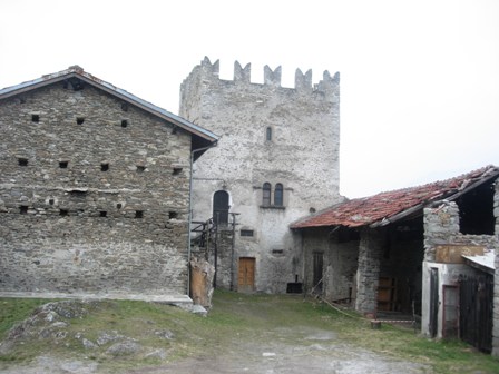
Stone houses cluster around a commanding castle ruin on a rise above the valley floor, their roofs worn grey by centuries. This is San Giorio di Susa, a village of fewer than a thousand souls where the Val di Susa narrows between the Alps, and where a medieval stronghold still dominates the landscape from its ancient moulé—the local name for the rocky knolls that punctuate the valley plain.
San Giorio di Susa village in Piedmont sits at 420 metres in the Turin metropolitan area, where its territory stretches upward to peaks beyond 2,800 metres. Visitors drawn here discover a place where 13th-century fortifications stand alongside frescoed chapels and living folk traditions that are performed each spring, anchoring the village to a pre-industrial past that locals have chosen to preserve.
Foundation and Medieval Identity
A document dated 20 February 1226, now held in the Turin State Archive, marks the official founding moment of San Giorio. Count Tommaso I of Savoy announced the establishment of a new settlement on the Mollare, the rocky prominence where the church of San Giorio already stood. The act was witnessed by local nobles including Beltramino Bertrandi, whose family would later govern the territory on behalf of the Savoy dynasty. According to historian Luca Patria, the settlement itself had been fragmented around the year 1000, with the church standing isolated on the heights. The villanova of 1226 gave it coherence and structure.
The village acquired strategic importance as a waypoint along the Via Francigena passing through Val di Susa, a role that Savoy house consolidated by placing the fief in the hands of the Bertrandi family. The 13th-century castle that still crowns the hillside embodied this feudal authority, though it suffered catastrophic destruction in 1691 at the hands of French general Catinat during the Nine Years’ War. Restoration work undertaken in the 1970s stabilized the ruins, and portions of the structure remain inhabited to this day.
Sacred Art and Architectural Monuments
Cappella del Conte
The jewel of San Giorio is the Cappella del Conte, a small chapel facing the parish church that guards some of the most vibrant frescoed surfaces in the valley. The interior walls display figures and scenes executed in the Franco-Piedmontese style and dated to 1328, their colours—reds, blues, golds—still luminous after nearly seven hundred years. These paintings lay hidden under later plaster until the 1970s, when restoration uncovered them unexpectedly. The chapel now serves as a detached seat of the diocesan museum of sacred art, allowing visitors to enter a compact space where medieval spiritual life speaks directly from pigment and wall.
Chiesa Parrocchiale di San Giorgio Martire
The parish church retains its original Romanesque bell tower, a squat stone structure with narrow windows that rises above the central square. The bell tower is one of the few elements surviving from earlier centuries, a physical link to the sacred geography that first drew settlements to this spot. The church interior holds a modest dignity appropriate to a village congregation, its layout and decoration reflecting the modest scale of the community it serves.
Casaforte
Standing on the hillside at an intermediate level between the castle and the parish church is the Casaforte, a fortified house marked by the distinctive dovetail crenellations typical of Alpine defensive architecture. Now owned by the parish, this structure belongs to a network of small fortifications that defended the valley, less monumental than the castle yet clearly built to resist assault. Its compact form and solid walls speak to an era when territorial authority relied on stone and vigilance.
Cappella di Maria Ausiliatrice
The Cappella di Maria Ausiliatrice in Borgata Pognant is documented in a 1643 record and representative of the many small devotional buildings scattered across the municipality’s 27 Alpine hamlets. These minor chapels, many accessible only by mountain paths, mark a tradition of private or neighbourhood worship that extended religious practice beyond the parish church into the dispersed communities of the high valleys.
Alpine Terrain and Mountain Passages
The municipality’s boundaries encompass a vertical span from 420 metres to 2,801 metres, tracking the shape of the Vallone del Gravio and the crests that define it. Twenty-seven Alpine hamlets—nine inhabited year-round—scatter across this terrain, connected by mule tracks, stone steps and narrow roads that wind upward through forests of chestnuts and mixed woodland. Beyond 1,250 metres, much of the territory falls within the Orsiera Rocciavrè Regional Nature Park, a protected zone that safeguards the peaks of Rocciavrè, Cristalliera and Villano. The localities of Adrit and Travè d’Amoun serve as departure points for mountain walkers, and the slopes remain worked for gneiss—a stone extracted in small quarries that dot the upper valleys—preserving a modest extractive tradition tied to the bedrock.
Traditions: The Living Past
Each spring, close to the feast of San Giorgio on 23 April, San Giorio stages a historical reenactment titled the Soppressione del Feudatario—the Suppression of the Feudal Lord. About a hundred costumed figures gather at the castle to perform a semi-mythical narrative: peasants rebelling against a Bertrandi nobleman who attempts to claim the jus primae noctis, the feudal right to the wedding night. The texts were composed by Don Attilio Bar, the village priest, and the music by Luigi “Viginet” Pognant Gros, the choir master, whose melodies and verses root the drama in local song traditions. First staged in 1929, the reenactment continues as a ceremonial assertion of popular dignity against old hierarchies, its medieval costumes and folk dances making visible a historical grievance.
Another tradition persists in the Danza degli Spadonari—the Sword Dance of the Sabru—figures whose origins lie in ancient fertility rites. Dancers in richly decorated garments topped with flower-adorned hats move in synchronized patterns, enacting rituals of spring renewal and field blessing whose exact provenance remains obscure. These two customs—one staged and textual, one dance-based and archaic—together form a cultural core that distinguishes San Giorio from neighbouring villages.
Food and Agricultural Rhythm
The territory’s abundance of chestnuts and woodland reflects an economy once rooted in gathering and small-scale forestry. The province of Turin claims several protected food products, among them the Marrone della Valle di Susa, a locally prized chestnut that grows well in this valley’s microclimate, and the Nocciola del Piemonte (IGP), hazelnuts cultivated across the broader region. While the Marrone della Valle di Susa lacks EU protected designation status, a Consortium exists for its valorization, though this does not constitute European protection. While San Giorio itself is not a named centre of production, the local landscape and seasonal rhythms align with these agricultural identities, and visitors will encounter chestnut-based preparations and hazelnut goods in the valley’s modest food culture.
Planning Your Visit
San Giorio lies in the heart of Val di Susa, a territory that draws walkers, cyclists and pilgrims year-round. Spring and early autumn offer the most comfortable conditions: the spring months allow visitors to experience the village during the approach to San Giorgio’s feast (23 April), when the medieval reenactment activates the castle and surrounding spaces. Summer brings dry weather and full access to mountain trails, while winter transforms the high hamlets into isolated communities accessible only by determined hikers. The village sits on historic pilgrimage routes—the Via Francigena and the Cammino di San Michele—both of which pass through Val di Susa, making San Giorio a natural rest point for walkers crossing the Alps.
| Departure | Distance | Estimated Time |
|---|---|---|
| Turin city centre | approximately 50 km | 50–60 minutes by car |
| Susa town centre | approximately 12 km | 15–20 minutes by car |
| Bussoleno railway station | approximately 8 km | 10–15 minutes by car |
Public transport connects Susa and Bussoleno (both on the Turin–Modane railway line) to regional bus services that reach the valley floor. Visitors arriving by car should note that the village centre is compact and best explored on foot; parking exists near the main church and castle approaches. The official website at comune.sangioriodisusa.to.it offers municipal information and seasonal event details. Nearby villages such as Borgone Susa and Novalesa provide additional exploration options within the same valley system.